IMAGES TAKEN NEAR TO
Malleable Way, STOCKTON-ON-TEES, TS18 2QX
Introduction
This page details the photographs taken nearby to Malleable Way, TS18 2QX by members of the Geograph project.
The Geograph project started in 2005 with the aim of publishing, organising and preserving representative images for every square kilometre of Great Britain, Ireland and the Isle of Man.

There are currently over 7.5m images from over14,400 individuals and you can help contribute to the project by visiting https://www.geograph.org.uk
Image Map
Images are licensed for reuse under creativecommons.org/licenses/by-sa/2.0
Notes
- Clicking on the map will re-center to the selected point.
- The higher the marker number, the further away the image location is from the centre of the postcode.
Image Listing (9 Images Found)
Images are licensed for reuse under creativecommons.org/licenses/by-sa/2.0
Image
Details
Distance
1
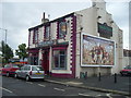
Traditional Pub
Located near the old Portrack bus depot. Several other old pubs in the local area have recently closed.
Image: © Ian Barton
Taken: 9 Aug 2008
0.09 miles
2
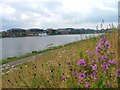
North Bank of the River Tees
Once an area of extensive industrial activity the north bank of Tees is currently undergoing reclamation. The south bank (far bank) has already undergone such transformation.
The northing follows the centre of the Tees cutting the south bank just to the right of the cruise boat that now plys the river.
Image: © Mick Garratt
Taken: 7 Jul 2005
0.11 miles
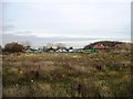
3
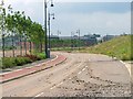
North Bank Reclamation
This area of the north bank of the Tees is undergoing extensive reclamation. This is a new road that's just been constructed but not yet handed over.
Image: © Mick Garratt
Taken: 7 Jul 2005
0.11 miles
4
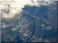
Stockton-on-Tees from the air
HMP Holme House can be seen on the left, Teeside retail park and Showcase Cinema are on the right, surrounded by Teeside Golf Club. Viewed from a Prague bound flight from Glasgow.
Image: © Thomas Nugent
Taken: 24 Sep 2018
0.11 miles
5
Children's Playground at St Ann's Hill
Image: © Eirian Evans
Taken: 15 Sep 2021
0.13 miles
6
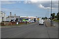
Traffic lights on the A1046
Looking along Portrack Lane at the junction with Malleable Way.
Image: © DS Pugh
Taken: 1 Aug 2016
0.17 miles
7
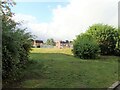
Whitewater Glade, Persimmon Homes Development
Image: © Alex McGregor
Taken: 30 Nov 2011
0.22 miles
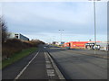
9

Portrack Lane
Tin shed land, Stockton. Portrack Lane is the dual carriageway A1046.
Image: © Richard Webb
Taken: 10 Aug 2016
0.25 miles