IMAGES TAKEN NEAR TO
Northport Road, STOCKTON-ON-TEES, TS18 2HX
Introduction
This page details the photographs taken nearby to Northport Road, TS18 2HX by members of the Geograph project.
The Geograph project started in 2005 with the aim of publishing, organising and preserving representative images for every square kilometre of Great Britain, Ireland and the Isle of Man.

There are currently over 7.5m images from over14,400 individuals and you can help contribute to the project by visiting https://www.geograph.org.uk
Image Map (Loading...)


Getting Data...Please wait
Leaflet Map data © OpenStreetMap
Images are licensed for reuse under creativecommons.org/licenses/by-sa/2.0
Notes
- Clicking on the map will re-center to the selected point.
- The higher the marker number, the further away the image location is from the centre of the postcode.
Image Listing (2 Images Found)
Images are licensed for reuse under creativecommons.org/licenses/by-sa/2.0
Image
Details
Distance
1
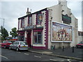
Traditional Pub
Located near the old Portrack bus depot. Several other old pubs in the local area have recently closed.
Image: © Ian Barton
Taken: 9 Aug 2008
0.21 miles
2
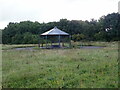
Pavilion in a Recreation Ground
Could not find a name for this green area. Lustrum Beck flows around it, but the whole are looks rather uncared for. The pavilion is covered in graffiti and has broken glass and an old shopping trolley.
Image: © Eirian Evans
Taken: 15 Sep 2021
0.23 miles