IMAGES TAKEN NEAR TO
Frederick Street, STOCKTON-ON-TEES, TS18 2BF
Introduction
This page details the photographs taken nearby to Frederick Street, TS18 2BF by members of the Geograph project.
The Geograph project started in 2005 with the aim of publishing, organising and preserving representative images for every square kilometre of Great Britain, Ireland and the Isle of Man.

There are currently over 7.5m images from over14,400 individuals and you can help contribute to the project by visiting https://www.geograph.org.uk
Image Map (Loading...)


Getting Data...Please wait
Leaflet Map data © OpenStreetMap
Images are licensed for reuse under creativecommons.org/licenses/by-sa/2.0
Notes
- Clicking on the map will re-center to the selected point.
- The higher the marker number, the further away the image location is from the centre of the postcode.
Image Listing (17 Images Found)
Images are licensed for reuse under creativecommons.org/licenses/by-sa/2.0
Image
Details
Distance
1
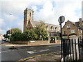
Church of St Mary
At the junction of North Road and Major Street. Roman Catholic church which opened in 1842.
Image: © Eirian Evans
Taken: 15 Sep 2021
0.12 miles
3
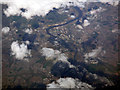
Stockton-on-Tees from the air
Looking down the River Tees from a Prague bound flight from Glasgow. Riverside Stadium can be seen in the top right quadrant. Taken from a Prague bound flight from Glasgow.
Image: © Thomas Nugent
Taken: 16 Apr 2018
0.15 miles
4
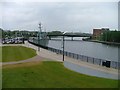
River Tees, Corporation Quay
Stockton's last remaining element of heritage as a port. The bridge is the Princess of Wales Bridge or the Diana Bridge and was opened in 1992. The ship which is permanently moored is the minesweeper HMS Kellington, the headquarters of Stockton Sea Cadets.
Image: © Mick Garratt
Taken: 14 Jun 2005
0.15 miles
6
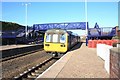
Train leaving Stockton station
This photograph shows a view of a train just starting to depart from Stockton railway station. It is heading in the direction of Eaglescliffe - the next station for south-bound trains. The picture was taken looking in a north-north-easterly direction towards Billingham Beck Valley Country Park.
Image: © Philip Barker
Taken: 10 Mar 2010
0.16 miles
7
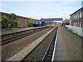
Stockton railway station, County Durham
Opened in 1852 by the Leeds Northern Railway on the line from Northallerton to Billingham, this station was expanded in 1893 when it received an overall roof.
View north east towards Billingham and Sunderland. The roof was removed in 1979, leaving just the substantial supporting wall to the left.
Image: © Nigel Thompson
Taken: 3 Nov 2012
0.17 miles
8
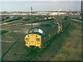
Primrose Hill Sidings, Stockton
The sidings were full of scrap railway wagons, most destined for the nearby Thomsons yard. Only two lines exist at this location today, an indictment of the decline of a proud railway system. Loco 37006 was passing on a local engineering train.
Image: © mark harrington
Taken: Unknown
0.18 miles
9
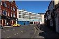
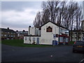
Bishopton Lane, Stockton
Bishopton Lane, a street on the edge of Stockton town centre.
Image: © Graham Robson
Taken: 6 Jul 2019
0.20 miles
10

Georgian terrace, Norton Road
Set within the town Conservation Area and having Grade 2 listed status.
Image: © Carol Rose
Taken: 6 Jul 2007
0.20 miles