IMAGES TAKEN NEAR TO
Farrer Street, STOCKTON-ON-TEES, TS18 2AW
Introduction
This page details the photographs taken nearby to Farrer Street, TS18 2AW by members of the Geograph project.
The Geograph project started in 2005 with the aim of publishing, organising and preserving representative images for every square kilometre of Great Britain, Ireland and the Isle of Man.

There are currently over 7.5m images from over14,400 individuals and you can help contribute to the project by visiting https://www.geograph.org.uk
Image Map (Loading...)


Getting Data...Please wait
Leaflet Map data © OpenStreetMap
Images are licensed for reuse under creativecommons.org/licenses/by-sa/2.0
Notes
- Clicking on the map will re-center to the selected point.
- The higher the marker number, the further away the image location is from the centre of the postcode.
Image Listing (46 Images Found)
Images are licensed for reuse under creativecommons.org/licenses/by-sa/2.0
Image
Details
Distance
1
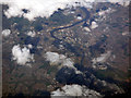
Stockton-on-Tees from the air
Looking down the River Tees from a Prague bound flight from Glasgow. Riverside Stadium can be seen in the top right quadrant. Taken from a Prague bound flight from Glasgow.
Image: © Thomas Nugent
Taken: 16 Apr 2018
0.04 miles
2
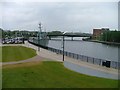
River Tees, Corporation Quay
Stockton's last remaining element of heritage as a port. The bridge is the Princess of Wales Bridge or the Diana Bridge and was opened in 1992. The ship which is permanently moored is the minesweeper HMS Kellington, the headquarters of Stockton Sea Cadets.
Image: © Mick Garratt
Taken: 14 Jun 2005
0.04 miles
3
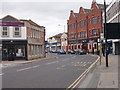
Bishopton Lane, Stockton
Bishopton Lane, a street on the edge of Stockton town centre.
Image: © Graham Robson
Taken: 6 Jul 2019
0.08 miles
4

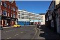
Georgian terrace, Norton Road
Set within the town Conservation Area and having Grade 2 listed status.
Image: © Carol Rose
Taken: 6 Jul 2007
0.09 miles
5
Norton Road - viewed from Bishopton Lane
Image: © Betty Longbottom
Taken: 25 Jul 2017
0.10 miles
6
Bishopton Lane - viewed from High Street
Image: © Betty Longbottom
Taken: 25 Jul 2017
0.10 miles
7
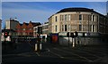
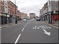
Maxwell's Corner
The junction of Bishopton Lane with the north end of the High Street has been known as Maxwell's Corner since E S Maxwell acquired the business of John Peckton, tailor, outfitter, hatter, hosier and glover, in 1913.
Image: © Mick Garratt
Taken: 25 Jan 2007
0.11 miles
8
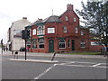
The North Eastern - Bishopton Lane
Image: © Betty Longbottom
Taken: 25 Jul 2017
0.12 miles
10
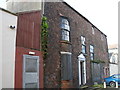
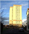
Semi derelict Georgian house
On Smith Street. I have lived near Stockton for 29 Years and Have never noticed this example of a bow fronted Georgian house. This part of Stockton is mainly car parks and truncated old roads.
Image: © Carol Rose
Taken: 6 Jul 2007
0.13 miles