IMAGES TAKEN NEAR TO
Snowdrop Place, STOCKTON-ON-TEES, TS18 1HZ
Introduction
This page details the photographs taken nearby to Snowdrop Place, TS18 1HZ by members of the Geograph project.
The Geograph project started in 2005 with the aim of publishing, organising and preserving representative images for every square kilometre of Great Britain, Ireland and the Isle of Man.

There are currently over 7.5m images from over14,400 individuals and you can help contribute to the project by visiting https://www.geograph.org.uk
Image Map
Images are licensed for reuse under creativecommons.org/licenses/by-sa/2.0
Notes
- Clicking on the map will re-center to the selected point.
- The higher the marker number, the further away the image location is from the centre of the postcode.
Image Listing (19 Images Found)
Images are licensed for reuse under creativecommons.org/licenses/by-sa/2.0
Image
Details
Distance
1
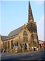
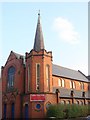
Stockton United Reformed Church, St Andrew & St George
Image: © Bill Henderson
Taken: 20 Feb 2008
0.08 miles
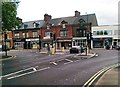
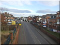
3
Yarm Lane
A busy road through Stockton. The church is the Image] according to Bill's photo.
Image: © Mick Garratt
Taken: 6 Aug 2008
0.13 miles
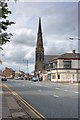
5
Lightfoot Grove Church, Stockton on Tees
Image: © Bill Henderson
Taken: 20 Feb 2008
0.16 miles
7

Churchyard of the Holy Trinity
The church, gutted by fire in 1991, is currently undergoing restoration and is enveloped in scaffolding.
Image: © Mick Garratt
Taken: 6 Aug 2008
0.18 miles
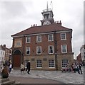
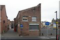
9
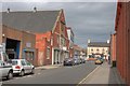
Skinner Street
The interesting building on the left is a nursery.
Image: © Mick Garratt
Taken: 6 Aug 2008
0.19 miles
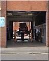
10
Neata Aquatics
Neata Aquatics, West Row, Stockton-on-Tees, Cleveland
Image: © Kevin Hale
Taken: 5 Jun 2009
0.20 miles