IMAGES TAKEN NEAR TO
St. Bernard Road, STOCKTON-ON-TEES, TS18 1HL
Introduction
This page details the photographs taken nearby to St. Bernard Road, TS18 1HL by members of the Geograph project.
The Geograph project started in 2005 with the aim of publishing, organising and preserving representative images for every square kilometre of Great Britain, Ireland and the Isle of Man.

There are currently over 7.5m images from over14,400 individuals and you can help contribute to the project by visiting https://www.geograph.org.uk
Image Map (Loading...)


Getting Data...Please wait
Leaflet Map data © OpenStreetMap
Images are licensed for reuse under creativecommons.org/licenses/by-sa/2.0
Notes
- Clicking on the map will re-center to the selected point.
- The higher the marker number, the further away the image location is from the centre of the postcode.
Image Listing (12 Images Found)
Images are licensed for reuse under creativecommons.org/licenses/by-sa/2.0
Image
Details
Distance
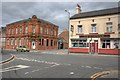
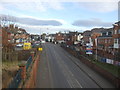
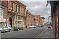
4
Skinner Street
The interesting building on the left is a nursery.
Image: © Mick Garratt
Taken: 6 Aug 2008
0.18 miles
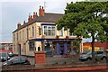
5
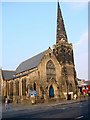
Stockton United Reformed Church, St Andrew & St George
Image: © Bill Henderson
Taken: 20 Feb 2008
0.18 miles
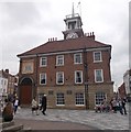
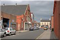
8
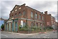
Former Brunswick Methodist Chapel
A Grade II listed building dating from 1823, designed by W. Sherwood and in a very bad state of repair. It is listed by English Heritage as being at risk see http://www.english-heritage.org.uk/upload/pdf/HAR_Register_NE_Acc.pdf
Image: © Mick Garratt
Taken: 6 Aug 2008
0.20 miles