IMAGES TAKEN NEAR TO
The Green, STOCKTON-ON-TEES, TS17 8PX
Introduction
This page details the photographs taken nearby to The Green, TS17 8PX by members of the Geograph project.
The Geograph project started in 2005 with the aim of publishing, organising and preserving representative images for every square kilometre of Great Britain, Ireland and the Isle of Man.

There are currently over 7.5m images from over14,400 individuals and you can help contribute to the project by visiting https://www.geograph.org.uk
Image Map
Images are licensed for reuse under creativecommons.org/licenses/by-sa/2.0
Notes
- Clicking on the map will re-center to the selected point.
- The higher the marker number, the further away the image location is from the centre of the postcode.
Image Listing (9 Images Found)
Images are licensed for reuse under creativecommons.org/licenses/by-sa/2.0
Image
Details
Distance
4
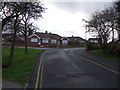
Richardson Road
At its junction with Lawrence Road
Image: © Graham Hogg
Taken: 4 Nov 2014
0.15 miles
5
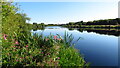
R Tees, upstream of Thornaby-on-Tees Church
Image: © Colin Park
Taken: 10 Aug 2022
0.16 miles
6
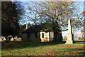
St Peter ad Vincula Church
This Anglican church on the village green dates from the 12th century
Image: © Graham Hogg
Taken: 4 Nov 2014
0.20 miles
7
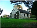
St. Peter's Church, Thornaby
A quaint church on Thornaby Green dating back to the Normans.
Image: © Mick Garratt
Taken: 16 Nov 2005
0.21 miles
8
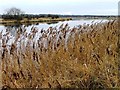
North Bank of the River Tees
View upstream
Image: © Mick Garratt
Taken: 5 Jan 2006
0.22 miles
9
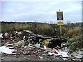
No Messing! No Dumping
Only a few paces from the accompanying photo Image Moments before I took this a Stockton Borough Council refuse wagon was parked up having a tea break.
Image: © Mick Garratt
Taken: 5 Jan 2006
0.24 miles