IMAGES TAKEN NEAR TO
Clarendon Road, STOCKTON-ON-TEES, TS17 8JJ
Introduction
This page details the photographs taken nearby to Clarendon Road, TS17 8JJ by members of the Geograph project.
The Geograph project started in 2005 with the aim of publishing, organising and preserving representative images for every square kilometre of Great Britain, Ireland and the Isle of Man.

There are currently over 7.5m images from over14,400 individuals and you can help contribute to the project by visiting https://www.geograph.org.uk
Image Map
Images are licensed for reuse under creativecommons.org/licenses/by-sa/2.0
Notes
- Clicking on the map will re-center to the selected point.
- The higher the marker number, the further away the image location is from the centre of the postcode.
Image Listing (12 Images Found)
Images are licensed for reuse under creativecommons.org/licenses/by-sa/2.0
Image
Details
Distance
1
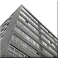
Thornaby Town Centre Flats
One of the pair of blocks of flats in Thornaby New Town Centre.
Image: © Andrew Mellor
Taken: Unknown
0.16 miles
2
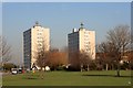
Thornaby Tower Blocks
A local landmark.
Image: © Mick Garratt
Taken: 13 Feb 2008
0.18 miles
3
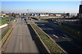
Millbank Lane
Passing to the left of the fire station training tower.
Image: © Mick Garratt
Taken: 13 Feb 2008
0.22 miles
4
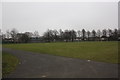
Village Park in Thornaby-on-Tees
This photograph shows a view of a part of Village Park which is located in the central part of Thornaby-on-Tees - just east of the River Tees and the A1045 road. This picture was taken from the Park Road entrance looking in a south-easterly direction towards Stainsby Grange Farm.
Image: © Philip Barker
Taken: 17 Feb 2010
0.22 miles
5
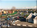
Mitchell Avenue, Thornaby-on-Tees
View north east from the walkway above the shops at the junction to Allensway. The run down complex on the right is a former car showrooms which has been in that state for years.
Image: © Mick Garratt
Taken: 29 Nov 2005
0.23 miles
6
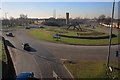
Thornaby Island
Trenchard Avenue off to the left, Millbank Lane straight on passing to the right of the fire station training tower.
Image: © Mick Garratt
Taken: 13 Feb 2008
0.23 miles
9
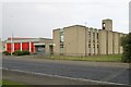
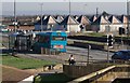
Thornaby fire station
Thornaby fire station, Master Road, Thornaby, Stockton, Cleveland
Image: © Kevin Hale
Taken: 5 Jun 2009
0.24 miles
10
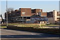
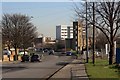
Thornaby Town Centre
Built in the 1960s and now due to be demolished in the rejuvenation of the town centre. An artist's impression can be seen on the billboard.
Image: © Mick Garratt
Taken: 13 Feb 2008
0.24 miles