IMAGES TAKEN NEAR TO
Acklam Road, STOCKTON-ON-TEES, TS17 7LD
Introduction
This page details the photographs taken nearby to Acklam Road, TS17 7LD by members of the Geograph project.
The Geograph project started in 2005 with the aim of publishing, organising and preserving representative images for every square kilometre of Great Britain, Ireland and the Isle of Man.

There are currently over 7.5m images from over14,400 individuals and you can help contribute to the project by visiting https://www.geograph.org.uk
Image Map (Loading...)


Getting Data...Please wait
Leaflet Map data © OpenStreetMap
Images are licensed for reuse under creativecommons.org/licenses/by-sa/2.0
Notes
- Clicking on the map will re-center to the selected point.
- The higher the marker number, the further away the image location is from the centre of the postcode.
Image Listing (11 Images Found)
Images are licensed for reuse under creativecommons.org/licenses/by-sa/2.0
Image
Details
Distance
1
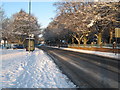
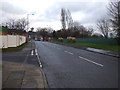
Snow-bound A1130 at Thornaby Cemetery (view north-west)
The A1130 road runs across the north-eastern edge of Thornaby-on-Tees. This photograph shows the status of the road after a recent snowfall. The picture was taken looking in a north-westerly direction towards Stockton-on-Tees. Thornaby Cemetery can be seen on the right-hand side of the picture. The recreation ground is just visible on the left-hand side of the picture behind the blue car.
Image: © Philip Barker
Taken: 20 Dec 2009
0.04 miles
2
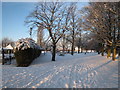
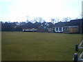
Snow-bound recreation ground in Thornaby-on-Tees
This photograph shows a part of Thornaby Recreation Ground after recent falls of snow in the North East of England. Both the children's area (in the centre) and the bowling green (on the left) seem to have taken a good covering of snow.
Image: © Philip Barker
Taken: 20 Dec 2009
0.05 miles


5
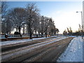
Snow-bound A1130 at Thornaby Cemetery (view south-east)
The A1130 road runs across the north-eastern edge of Thornaby-on-Tees. This photograph shows the status of the road after a recent snowfall. The picture was taken looking in a south-easterly direction towards Whinney Banks. Thornaby Cemetery can be seen on the left-hand side of the road. The traffic lights at the road junction are also visible.
Image: © Philip Barker
Taken: 20 Dec 2009
0.12 miles
7
Lanehouse Road, Thornaby-on-Tees
Heading east.
Image: © JThomas
Taken: 15 Dec 2012
0.12 miles
8
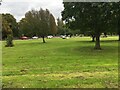
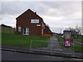
Thornaby on Tees Cricket Club
Next to the Teeside Golf Club
Image: © Michael Graham
Taken: 11 Mar 2010
0.14 miles
10

Thornaby cemetery
Thornaby cemetery as the sun is setting highlighting the Poplar trees.
Image: © John Peacock
Taken: 27 Nov 2020
0.20 miles