IMAGES TAKEN NEAR TO
Victoria Road, STOCKTON-ON-TEES, TS17 6HW
Introduction
This page details the photographs taken nearby to Victoria Road, TS17 6HW by members of the Geograph project.
The Geograph project started in 2005 with the aim of publishing, organising and preserving representative images for every square kilometre of Great Britain, Ireland and the Isle of Man.

There are currently over 7.5m images from over14,400 individuals and you can help contribute to the project by visiting https://www.geograph.org.uk
Image Map (Loading...)


Getting Data...Please wait
Leaflet Map data © OpenStreetMap
Images are licensed for reuse under creativecommons.org/licenses/by-sa/2.0
Notes
- Clicking on the map will re-center to the selected point.
- The higher the marker number, the further away the image location is from the centre of the postcode.
Image Listing (8 Images Found)
Images are licensed for reuse under creativecommons.org/licenses/by-sa/2.0
Image
Details
Distance
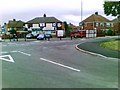
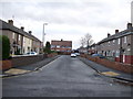
2
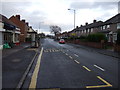
Lanehouse Road, Thornaby-on-Tees
Heading east.
Image: © JThomas
Taken: 15 Dec 2012
0.15 miles
5
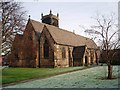
Church of St Paul the Apostle, Thornaby
This photograph of the church in North Thornaby was taken from just inside the church grounds near the junction of Cambridge Road with Thornaby Road (A1045). Notice the two different 'colours' of the grass: that on the right has an early-morning frost while that on the left has thawed out.
Image: © Philip Barker
Taken: 19 Jan 2010
0.18 miles
6
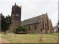
Thornaby on Tees, North Yorkshire, St Paul
Image: © Dave Kelly
Taken: 13 Jul 2018
0.21 miles
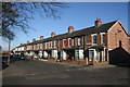
7
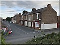
Gilmour Street, Thornaby
Terraced houses on Gilmour Street.
Image: © David Robinson
Taken: 12 Jul 2019
0.22 miles