IMAGES TAKEN NEAR TO
Dubris Close, STOCKTON-ON-TEES, TS17 5JP
Introduction
This page details the photographs taken nearby to Dubris Close, TS17 5JP by members of the Geograph project.
The Geograph project started in 2005 with the aim of publishing, organising and preserving representative images for every square kilometre of Great Britain, Ireland and the Isle of Man.

There are currently over 7.5m images from over14,400 individuals and you can help contribute to the project by visiting https://www.geograph.org.uk
Image Map (Loading...)


Getting Data...Please wait
Leaflet Map data © OpenStreetMap
Images are licensed for reuse under creativecommons.org/licenses/by-sa/2.0
Notes
- Clicking on the map will re-center to the selected point.
- The higher the marker number, the further away the image location is from the centre of the postcode.
Image Listing (5 Images Found)
Images are licensed for reuse under creativecommons.org/licenses/by-sa/2.0
Image
Details
Distance
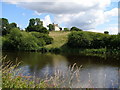
1
Bridleway to Barwick Farm
Looking past Sand Hill towards an unnamed plantation on the bridleway to Barwick Farm
Image: © Graham Scarborough
Taken: 2 Feb 2008
0.12 miles
2
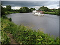
Teesside Princess by Eaglescliffe Golf Course
Pleasure craft that plies the River Tees between Stockton and Yarm.
Image: © Chris Heaton
Taken: 7 Jul 2010
0.18 miles