IMAGES TAKEN NEAR TO
Leazon Hill, STOCKTON-ON-TEES, TS17 5AS
Introduction
This page details the photographs taken nearby to Leazon Hill, TS17 5AS by members of the Geograph project.
The Geograph project started in 2005 with the aim of publishing, organising and preserving representative images for every square kilometre of Great Britain, Ireland and the Isle of Man.

There are currently over 7.5m images from over14,400 individuals and you can help contribute to the project by visiting https://www.geograph.org.uk
Image Map
Images are licensed for reuse under creativecommons.org/licenses/by-sa/2.0
Notes
- Clicking on the map will re-center to the selected point.
- The higher the marker number, the further away the image location is from the centre of the postcode.
Image Listing (6 Images Found)
Images are licensed for reuse under creativecommons.org/licenses/by-sa/2.0
Image
Details
Distance
3
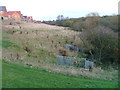
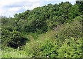
Green Corridor Leading North to Thornaby Wood ...
... through Ingleby Barwick supposedly Europe's largest private housing estate.
Image: © Mick Garratt
Taken: 24 Nov 2005
0.12 miles
5
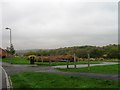
Footpath to Thornaby Wood
The footpath heads off from the road toward Thornaby Wood, following a local stream.
Image: © Graham Scarborough
Taken: 29 Jun 2008
0.17 miles
6
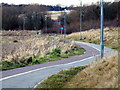
Cycle Path
This cycle path runs adjacent to the old footpath called Bassleton Lane
Image: © Graham Scarborough
Taken: 28 Dec 2008
0.22 miles