IMAGES TAKEN NEAR TO
Ingleby Barwick, STOCKTON-ON-TEES, TS17 5AD
Introduction
This page details the photographs taken nearby to TS17 5AD by members of the Geograph project.
The Geograph project started in 2005 with the aim of publishing, organising and preserving representative images for every square kilometre of Great Britain, Ireland and the Isle of Man.

There are currently over 7.5m images from over14,400 individuals and you can help contribute to the project by visiting https://www.geograph.org.uk
Image Map
Images are licensed for reuse under creativecommons.org/licenses/by-sa/2.0
Notes
- Clicking on the map will re-center to the selected point.
- The higher the marker number, the further away the image location is from the centre of the postcode.
Image Listing (7 Images Found)
Images are licensed for reuse under creativecommons.org/licenses/by-sa/2.0
Image
Details
Distance

4
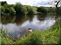
The compleat angler by the Tees
No, he is not naked, just enjoying the first bit of sun in 5 weeks in the summer of 2007!
Image: © Carol Rose
Taken: 7 Jul 2007
0.12 miles
5
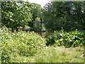
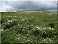
Teesdale Way opposite Roundhill Village
A floral extravaganza awaits the walker along this section of the Teesdale Way.
Image: © Chris Heaton
Taken: 7 Jul 2010
0.15 miles
6
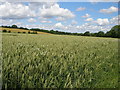
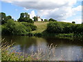
Looking across arable land towards the trees of Eaglescliffe golf course
Image: © Carol Rose
Taken: 7 Jul 2007
0.20 miles
7
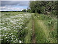
Floral Display near Eaglescliffe
Fields full of wild flowers beside the River Tees between Eaglescliffe and Roundhill.
Image: © Chris Heaton
Taken: 7 Jul 2010
0.20 miles