IMAGES TAKEN NEAR TO
Barwick Way, STOCKTON-ON-TEES, TS17 0WD
Introduction
This page details the photographs taken nearby to Barwick Way, TS17 0WD by members of the Geograph project.
The Geograph project started in 2005 with the aim of publishing, organising and preserving representative images for every square kilometre of Great Britain, Ireland and the Isle of Man.

There are currently over 7.5m images from over14,400 individuals and you can help contribute to the project by visiting https://www.geograph.org.uk
Image Map
Images are licensed for reuse under creativecommons.org/licenses/by-sa/2.0
Notes
- Clicking on the map will re-center to the selected point.
- The higher the marker number, the further away the image location is from the centre of the postcode.
Image Listing (7 Images Found)
Images are licensed for reuse under creativecommons.org/licenses/by-sa/2.0
Image
Details
Distance
1
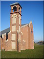
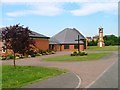
Bell Tower and Church
St. Francis of Assisi parish Church and Bell Tower in Ingleby Barwick. The church was built in 2004
Image: © Michael Graham
Taken: 11 Mar 2010
0.03 miles
2
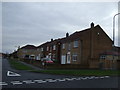
Barwick Way
By The Parish Church of St. Francis of Assisi looking down Barwick way in Ingleby Barwick.
Image: © Michael Graham
Taken: 11 Mar 2010
0.04 miles
3
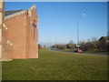
Proposed site for Romano Park - "Landscape for Play" area
This is the green area behind Tesco which is part of the proposed site for Romano Park in Ingleby Barwick. This area will become the "Landscape for Play" part of the park.
Image: © Graham Scarborough
Taken: 29 Jun 2008
0.05 miles
4
Parish Church of St Francis of Assisi, Ingleby Barwick
Image: © Mick Garratt
Taken: 13 Jul 2005
0.10 miles
5
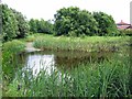
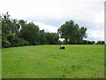
Barwick Pond
Barwick Pond Local Nature Reserve.
Image: © Graham Scarborough
Taken: 29 Jun 2008
0.13 miles
6
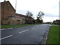
Beckfields Avenue, Ingleby Barwick
Heading West.
Image: © JThomas
Taken: 8 Dec 2012
0.22 miles