IMAGES TAKEN NEAR TO
Westwood Lane, STOCKTON-ON-TEES, TS17 0UY
Introduction
This page details the photographs taken nearby to Westwood Lane, TS17 0UY by members of the Geograph project.
The Geograph project started in 2005 with the aim of publishing, organising and preserving representative images for every square kilometre of Great Britain, Ireland and the Isle of Man.

There are currently over 7.5m images from over14,400 individuals and you can help contribute to the project by visiting https://www.geograph.org.uk
Image Map (Loading...)


Getting Data...Please wait
Leaflet Map data © OpenStreetMap
Images are licensed for reuse under creativecommons.org/licenses/by-sa/2.0
Notes
- Clicking on the map will re-center to the selected point.
- The higher the marker number, the further away the image location is from the centre of the postcode.
Image Listing (9 Images Found)
Images are licensed for reuse under creativecommons.org/licenses/by-sa/2.0
Image
Details
Distance
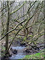
4
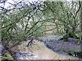
Bassleton Beck
Bassleton Beck as it runs through Thornaby Plantation. Originally a deciduous plantation of predominantly oak, it is now almost completely overgrown by Elder and Hawthorn.
Image: © Graham Scarborough
Taken: 2 Feb 2008
0.18 miles
5
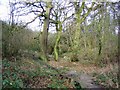
Footpath along Bassleton Beck
Footpath into the woods along Bassleton Beck
Image: © Graham Scarborough
Taken: 2 Feb 2008
0.18 miles
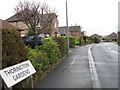
7
Path alongside Bassleton Beck
Path alongside Bassleton Beck on the east side of Ingleby Barwick
Image: © Graham Scarborough
Taken: 2 Feb 2008
0.22 miles
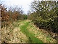
8
Bassleton Beck, looking south from Ingleby Way
Image: © Graham Scarborough
Taken: 29 Dec 2008
0.24 miles