IMAGES TAKEN NEAR TO
Pevensey Close, STOCKTON-ON-TEES, TS17 0NW
Introduction
This page details the photographs taken nearby to Pevensey Close, TS17 0NW by members of the Geograph project.
The Geograph project started in 2005 with the aim of publishing, organising and preserving representative images for every square kilometre of Great Britain, Ireland and the Isle of Man.

There are currently over 7.5m images from over14,400 individuals and you can help contribute to the project by visiting https://www.geograph.org.uk
Image Map
Images are licensed for reuse under creativecommons.org/licenses/by-sa/2.0
Notes
- Clicking on the map will re-center to the selected point.
- The higher the marker number, the further away the image location is from the centre of the postcode.
Image Listing (7 Images Found)
Images are licensed for reuse under creativecommons.org/licenses/by-sa/2.0
Image
Details
Distance
1
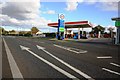
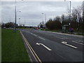
Filling station on the A1044 road
This photograph shows a view of the Esso petrol station on the A1044 road near Little Maltby Farm. The picture was taken looking in an east-north-easterly direction towards Thornton.
Image: © Philip Barker
Taken: 18 Sep 2010
0.09 miles
2
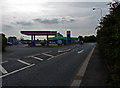
Esso Station on Low Lane
Also a Co-op food store
Image: © Graham Scarborough
Taken: 4 Sep 2010
0.14 miles
5
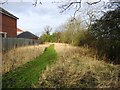
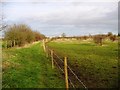
Path alongside Bassleton Beck
Path alongside Bassleton Beck on the edge of Ingleby Barwick
Image: © Graham Scarborough
Taken: 2 Feb 2008
0.15 miles