IMAGES TAKEN NEAR TO
Millbank Lane, STOCKTON-ON-TEES, TS17 0BG
Introduction
This page details the photographs taken nearby to Millbank Lane, TS17 0BG by members of the Geograph project.
The Geograph project started in 2005 with the aim of publishing, organising and preserving representative images for every square kilometre of Great Britain, Ireland and the Isle of Man.

There are currently over 7.5m images from over14,400 individuals and you can help contribute to the project by visiting https://www.geograph.org.uk
Image Map (Loading...)


Getting Data...Please wait
Leaflet Map data © OpenStreetMap
Images are licensed for reuse under creativecommons.org/licenses/by-sa/2.0
Notes
- Clicking on the map will re-center to the selected point.
- The higher the marker number, the further away the image location is from the centre of the postcode.
Image Listing (8 Images Found)
Images are licensed for reuse under creativecommons.org/licenses/by-sa/2.0
Image
Details
Distance
2
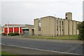
Master Road
The building nearest has a date of 1931 on it making it contemporary with the aerodrome on which Thornaby new town is built.
Image: © Mick Garratt
Taken: 13 Feb 2008
0.07 miles
3
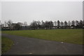
Village Park in Thornaby-on-Tees
This photograph shows a view of a part of Village Park which is located in the central part of Thornaby-on-Tees - just east of the River Tees and the A1045 road. This picture was taken from the Park Road entrance looking in a south-easterly direction towards Stainsby Grange Farm.
Image: © Philip Barker
Taken: 17 Feb 2010
0.08 miles
4
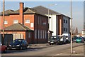
Thornaby fire station
Thornaby fire station, Master Road, Thornaby, Stockton, Cleveland
Image: © Kevin Hale
Taken: 5 Jun 2009
0.20 miles
5
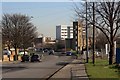
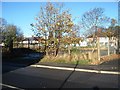
Millbank Lane
Passing to the left of the fire station training tower.
Image: © Mick Garratt
Taken: 13 Feb 2008
0.21 miles
6
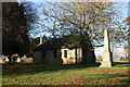
St Peter ad Vincula Church
This Anglican church on the village green dates from the 12th century
Image: © Graham Hogg
Taken: 4 Nov 2014
0.24 miles
7
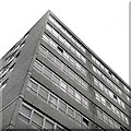
Thornaby Town Centre Flats
One of the pair of blocks of flats in Thornaby New Town Centre.
Image: © Andrew Mellor
Taken: Unknown
0.24 miles
8
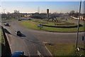
Thornaby Island
Trenchard Avenue off to the left, Millbank Lane straight on passing to the right of the fire station training tower.
Image: © Mick Garratt
Taken: 13 Feb 2008
0.25 miles