IMAGES TAKEN NEAR TO
Monmouth Drive, STOCKTON-ON-TEES, TS16 9HU
Introduction
This page details the photographs taken nearby to Monmouth Drive, TS16 9HU by members of the Geograph project.
The Geograph project started in 2005 with the aim of publishing, organising and preserving representative images for every square kilometre of Great Britain, Ireland and the Isle of Man.

There are currently over 7.5m images from over14,400 individuals and you can help contribute to the project by visiting https://www.geograph.org.uk
Image Map (Loading...)


Getting Data...Please wait
Leaflet Map data © OpenStreetMap
Images are licensed for reuse under creativecommons.org/licenses/by-sa/2.0
Notes
- Clicking on the map will re-center to the selected point.
- The higher the marker number, the further away the image location is from the centre of the postcode.
Image Listing (5 Images Found)
Images are licensed for reuse under creativecommons.org/licenses/by-sa/2.0
Image
Details
Distance
1

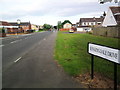
Footpath from Sunningdale Drive, Eaglescliffe
This footpath heads south, between Aberdovey Drive and Fort Rose Close towards Hoylake Way.
Image: © Rich Tea
Taken: 16 Jun 2010
0.22 miles
2
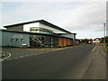
Eaglescliffe Health Centre
At the corner of Sunningdale Drive and Muirfield Road.
See their website http://www.eaglescliffemedical.co.uk/
Image: © Rich Tea
Taken: 16 Jun 2010
0.23 miles
3
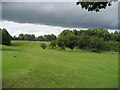
Thirteenth Fairway Eaglescliffe Golf Course
Part of the golf course, sandwiched between the community of Eaglescliffe and the River Tees.
Image: © Chris Heaton
Taken: 7 Jul 2010
0.23 miles
4
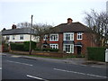
Sunningdale Drive, Eaglescliffe
With the Pavilion on the left.
Taken from the junction with Parkstone Place
Image: © Rich Tea
Taken: 16 Jun 2010
0.23 miles