IMAGES TAKEN NEAR TO
Sowerby Way, STOCKTON-ON-TEES, TS16 0RB
Introduction
This page details the photographs taken nearby to Sowerby Way, TS16 0RB by members of the Geograph project.
The Geograph project started in 2005 with the aim of publishing, organising and preserving representative images for every square kilometre of Great Britain, Ireland and the Isle of Man.

There are currently over 7.5m images from over14,400 individuals and you can help contribute to the project by visiting https://www.geograph.org.uk
Image Map (Loading...)


Getting Data...Please wait
Leaflet Map data © OpenStreetMap
Images are licensed for reuse under creativecommons.org/licenses/by-sa/2.0
Notes
- Clicking on the map will re-center to the selected point.
- The higher the marker number, the further away the image location is from the centre of the postcode.
Image Listing (4 Images Found)
Images are licensed for reuse under creativecommons.org/licenses/by-sa/2.0
Image
Details
Distance
2
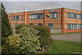
Oakwood Christian Centre
The former Commodore factory has been converted for use as a Christian Centre. Providing rooms for community groups the Tees Valley Community Church also meet here on Sundays
Image: © Peter Jeynes
Taken: 2 Apr 2007
0.22 miles
3
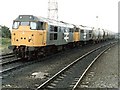
Eaglescliffe Junction
31184 and 31229 just clearing the junction with a tanker train
Image: © Dave Hitchborne
Taken: 17 Jun 1985
0.23 miles
4
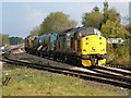
Leaf Removal Train, Eaglescliffe Station
This is one of the trains run annually in the Autumn to remove leaf mulch from the rails by using high-pressure water jets.
Image: © mark harrington
Taken: 16 Oct 2004
0.23 miles