IMAGES TAKEN NEAR TO
Croft Road, STOCKTON-ON-TEES, TS16 0DX
Introduction
This page details the photographs taken nearby to Croft Road, TS16 0DX by members of the Geograph project.
The Geograph project started in 2005 with the aim of publishing, organising and preserving representative images for every square kilometre of Great Britain, Ireland and the Isle of Man.

There are currently over 7.5m images from over14,400 individuals and you can help contribute to the project by visiting https://www.geograph.org.uk
Image Map
Images are licensed for reuse under creativecommons.org/licenses/by-sa/2.0
Notes
- Clicking on the map will re-center to the selected point.
- The higher the marker number, the further away the image location is from the centre of the postcode.
Image Listing (13 Images Found)
Images are licensed for reuse under creativecommons.org/licenses/by-sa/2.0
Image
Details
Distance
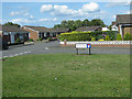
2
Marion Avenue, Eaglescliffe
Marion Avenue is a residential road in Eaglescliffe, on Teesside.
Image: © Malc McDonald
Taken: 3 Mar 2019
0.13 miles
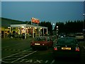
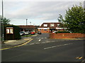
3

Tesco car park, Egglescliffe
Off Urlay Nook Road.
Image: © Pauline E
Taken: 16 Jun 2011
0.13 miles

5
Full Moon Over Tesco
A pity I only had the wide angle cheap digital camera!
Image: © mark harrington
Taken: 16 Nov 2005
0.20 miles
7
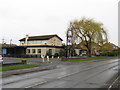
The Eagle pub, Eaglescliffe
The Eagle pub in Eaglescliffe, photographed on a wet day in March 2019.
Image: © Malc McDonald
Taken: 3 Mar 2019
0.22 miles
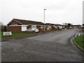
8
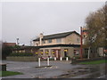
The Eagle, Durham Lane
Picture taken in pouring rain.
Image: © Jonathan Thacker
Taken: 26 Nov 2012
0.23 miles
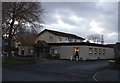
10
Pavilion, Sunningdale Drive, Eaglescliffe
The Pavilion is a pub, with shops to the left.
Image: © Rich Tea
Taken: 16 Jun 2010
0.23 miles