IMAGES TAKEN NEAR TO
St. Aidans Drive, MIDDLESBROUGH, TS1 5TS
Introduction
This page details the photographs taken nearby to St. Aidans Drive, TS1 5TS by members of the Geograph project.
The Geograph project started in 2005 with the aim of publishing, organising and preserving representative images for every square kilometre of Great Britain, Ireland and the Isle of Man.

There are currently over 7.5m images from over14,400 individuals and you can help contribute to the project by visiting https://www.geograph.org.uk
Image Map
Images are licensed for reuse under creativecommons.org/licenses/by-sa/2.0
Notes
- Clicking on the map will re-center to the selected point.
- The higher the marker number, the further away the image location is from the centre of the postcode.
Image Listing (151 Images Found)
Images are licensed for reuse under creativecommons.org/licenses/by-sa/2.0
Image
Details
Distance
5
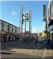
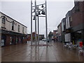
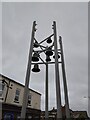
St. Hilda's Bells, Grange Road, Middlesbrough
Image: © habiloid
Taken: 1 Aug 2024
0.06 miles
6
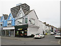
Baker Street, Middlesbrough
Baker Street in Middlesbrough.
The script on the side of the building refers to another Baker Street. The words are from The Five Orange Pips, a short story about the famous fictional detective Sherlock Holmes. Sherlock Holmes lived at a fictitious address, 221B Baker Street, but in London rather than Middlesbrough.
Image: © Malc McDonald
Taken: 3 Mar 2019
0.06 miles
7

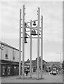
St Hilda's Bells
These bells - there are eight altogether - were cast in 1864 for St Hilda's Church which was demolished in 1969. After a period in storage and then at another site they were brought here to Grange Road in 2005.
Image: © Stephen McKay
Taken: 13 Oct 2012
0.06 miles
8
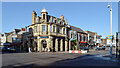
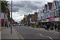
The junction of Borough Road and Linthorpe Road, Middlesbrough
The B1272 turns left from Linthorpe Road into Borough Road here.
Image: © habiloid
Taken: 29 Oct 2021
0.07 miles
9
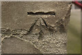
Cut Bench Mark, All Saints' Church, Middlesbrough
Bench Mark Database: http://www.bench-marks.org.uk/bm39652
Image: © Mark Anderson
Taken: 3 Jun 2016
0.07 miles
10
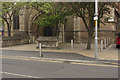
Western Elevation, All Saints' Church, Middlesbrough
There is a cut bench mark on the corner to the right of the photograph and a closer view can be seen here: Image
Image: © Mark Anderson
Taken: 3 Jun 2016
0.07 miles