IMAGES TAKEN NEAR TO
Howden Dike, YARM, TS15 9UP
Introduction
This page details the photographs taken nearby to Howden Dike, TS15 9UP by members of the Geograph project.
The Geograph project started in 2005 with the aim of publishing, organising and preserving representative images for every square kilometre of Great Britain, Ireland and the Isle of Man.

There are currently over 7.5m images from over14,400 individuals and you can help contribute to the project by visiting https://www.geograph.org.uk
Image Map (Loading...)


Getting Data...Please wait
Leaflet Map data © OpenStreetMap
Images are licensed for reuse under creativecommons.org/licenses/by-sa/2.0
Notes
- Clicking on the map will re-center to the selected point.
- The higher the marker number, the further away the image location is from the centre of the postcode.
Image Listing (17 Images Found)
Images are licensed for reuse under creativecommons.org/licenses/by-sa/2.0
Image
Details
Distance
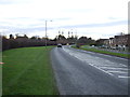
3
Kirk Road : Green Lane Junction
Looking from Kirk Road To Green Lane, the A1044, formerly the B1264 south-east of Yarm.
Image: © Hugh Mortimer
Taken: 2 Sep 2006
0.14 miles
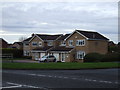
5
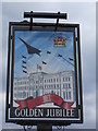
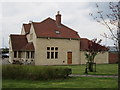
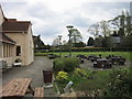
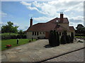
The Golden Jubilee, Yarm
The only Sam Smith's public house in Yarm.
Image: © Ian S
Taken: 7 May 2012
0.18 miles
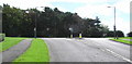
6
The Golden Jubilee, Yarn
A Sam Smith's public house.
Image: © Ian S
Taken: 29 Jun 2013
0.19 miles

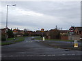
8
The Golden Jubilee, Yarm
The only Sam Smith's public house in Yarm.
Image: © Ian S
Taken: 7 May 2012
0.19 miles
9
The Golden Jubilee, Yarm
The only Sam Smith's public house in Yarm.
Image: © Ian S
Taken: 7 May 2012
0.19 miles
10
The Golden Jubilee, Yarn
A Sam Smith's public house.
Image: © Ian S
Taken: 29 Jun 2013
0.19 miles