IMAGES TAKEN NEAR TO
Castlelevington, YARM, TS15 9PD
Introduction
This page details the photographs taken nearby to TS15 9PD by members of the Geograph project.
The Geograph project started in 2005 with the aim of publishing, organising and preserving representative images for every square kilometre of Great Britain, Ireland and the Isle of Man.

There are currently over 7.5m images from over14,400 individuals and you can help contribute to the project by visiting https://www.geograph.org.uk
Image Map
Images are licensed for reuse under creativecommons.org/licenses/by-sa/2.0
Notes
- Clicking on the map will re-center to the selected point.
- The higher the marker number, the further away the image location is from the centre of the postcode.
Image Listing (2 Images Found)
Images are licensed for reuse under creativecommons.org/licenses/by-sa/2.0
Image
Details
Distance
1
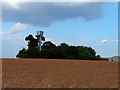
Communications Mast
Communications Mast off Redhall Lane
Image: © Graham Scarborough
Taken: 27 Aug 2010
0.12 miles
2
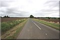
Minor road near Toft Hill
This photograph shows a view of a section of the minor road that runs between Kirklevington (behind the photographer) and the road junction near Foxton Lodge Farm. The picture was taken looking in an east-south-easterly direction towards Middleton Wood. The Cleveland hills are just visible on the horizon (right-hand side of image) as is the pylon run near Middleton-on-Leven (left-hand side of image).
Image: © Philip Barker
Taken: 25 Sep 2010
0.21 miles