IMAGES TAKEN NEAR TO
High Leven, YARM, TS15 9JU
Introduction
This page details the photographs taken nearby to TS15 9JU by members of the Geograph project.
The Geograph project started in 2005 with the aim of publishing, organising and preserving representative images for every square kilometre of Great Britain, Ireland and the Isle of Man.

There are currently over 7.5m images from over14,400 individuals and you can help contribute to the project by visiting https://www.geograph.org.uk
Image Map
Images are licensed for reuse under creativecommons.org/licenses/by-sa/2.0
Notes
- Clicking on the map will re-center to the selected point.
- The higher the marker number, the further away the image location is from the centre of the postcode.
Image Listing (7 Images Found)
Images are licensed for reuse under creativecommons.org/licenses/by-sa/2.0
Image
Details
Distance

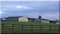
2
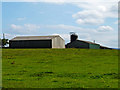
Barns on the Edge of White House Farm
Barns on the Edge of White House Farm. Taken from the footpath adjacent to the A19
Image: © Graham Scarborough
Taken: 5 Sep 2010
0.08 miles
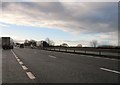
4

Tunnel under the A19
The tunnel forms part of the road to White House Farm. Taken from the North Side of the A19
Image: © Graham Scarborough
Taken: 5 Sep 2010
0.11 miles
5

Tunnel under the A19, taken from the south side of the A19
The tunnel forms part of the road to White House Farm.
Image: © Graham Scarborough
Taken: 5 Sep 2010
0.12 miles
7
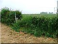
Public Footpath Sign and Stile on the Maltby to Hilton Road
Image: © Mick Garratt
Taken: 30 Jun 2005
0.21 miles