IMAGES TAKEN NEAR TO
Green Lane, YARM, TS15 9ET
Introduction
This page details the photographs taken nearby to Green Lane, TS15 9ET by members of the Geograph project.
The Geograph project started in 2005 with the aim of publishing, organising and preserving representative images for every square kilometre of Great Britain, Ireland and the Isle of Man.

There are currently over 7.5m images from over14,400 individuals and you can help contribute to the project by visiting https://www.geograph.org.uk
Image Map
Images are licensed for reuse under creativecommons.org/licenses/by-sa/2.0
Notes
- Clicking on the map will re-center to the selected point.
- The higher the marker number, the further away the image location is from the centre of the postcode.
Image Listing (17 Images Found)
Images are licensed for reuse under creativecommons.org/licenses/by-sa/2.0
Image
Details
Distance
1
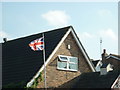
Upside down Union Flag #21
Field View bed & breakfast, Yarm.
Image: © Ian S
Taken: 22 Oct 2011
0.09 miles
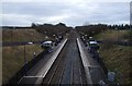
4
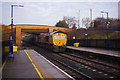
Freight train - Yarm Station
A GB Railfreight operated train from Thrislington Quarry in Co Durham to Chesterton in Cambridgeshire enters Yarm station. This is an important freight route for traffic originating on Teesside heading south and for avoiding a stretch of the East Coast Main Line.
Image: © Stephen McKay
Taken: 11 Dec 2018
0.14 miles
6
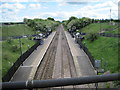
Yarm railway station
Opened in 1993 by British Rail on the line from Northallerton to Eaglescliffe, much further from the town centre than the previous Yarm station. View south towards Picton and Northallerton.
Image: © Nigel Thompson
Taken: 30 May 2010
0.15 miles
7
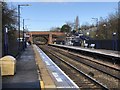
Yarm Railway Station
As of 2020 the station is served by TransPennine Express services on the Redcar - Manchester Airport route, and by Grand Central services on the Sunderland - London Kings Cross route.
Image: © David Robinson
Taken: 10 Feb 2020
0.15 miles
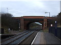
8
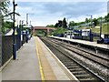
Yarm Railway Station
Yarm railway station is the station between Northallerton and Thornaby railway stations on the Northallerton to Eaglescliffe Line.
The bridge in the background is Green Lane Bridge which carries the B1264 from Yarm to the A167.
Image: © G Laird
Taken: 13 Jun 2018
0.15 miles
9
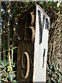
Old Milestone, B1264, Yarm
Out of place milestone on Green Lane, near Yarm railway station, serving as garden decoration. It would originally have read "Yᴹ 8". The original location was on the A167 Northallerton Road, near the Toll Bar Garage. CB is for Catterick Bridge, Yᴹ for Yarm.
Inscription: CB / 9 // Yᴹ 1
Milestone Society National ID: TBC
Image: © Hilary Jones
Taken: 23 Mar 2022
0.16 miles
10

Yarm Station
The station here was opened in 1996 some distance south of the original Yarm station which closed in 1960. No doubt the expectation was that most passengers would arrive by car, and a site was chosen where land was available to provide a sizeable car park (which is provided by the local authority, not the station operator). A walking route to the town centre (over a mile away) is signposted passing mainly through a housing estate and the nearest bus stop is on Davenport Road.
Image: © Stephen McKay
Taken: 11 Dec 2018
0.16 miles