IMAGES TAKEN NEAR TO
West Mews, YARM, TS15 9BN
Introduction
This page details the photographs taken nearby to West Mews, TS15 9BN by members of the Geograph project.
The Geograph project started in 2005 with the aim of publishing, organising and preserving representative images for every square kilometre of Great Britain, Ireland and the Isle of Man.

There are currently over 7.5m images from over14,400 individuals and you can help contribute to the project by visiting https://www.geograph.org.uk
Image Map
Images are licensed for reuse under creativecommons.org/licenses/by-sa/2.0
Notes
- Clicking on the map will re-center to the selected point.
- The higher the marker number, the further away the image location is from the centre of the postcode.
Image Listing (164 Images Found)
Images are licensed for reuse under creativecommons.org/licenses/by-sa/2.0
Image
Details
Distance
1
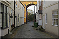
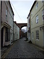
Low Church Wynd, Yarm
There are several 'wynds' leading off the High Street in Yarm. Originally the buildings here were seen as inferior dwellings to those on the High Street itself, but in more recent times they have become sought after. This is the most northerly wynd, leading through an arch of Yarm viaduct.
Image: © Stephen McKay
Taken: 10 Dec 2018
0.02 miles
2
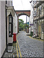
Low Church Wynd
A narrow, cobbled street passing under the Yarm Viaduct which carries the Middlesbrough to Northallerton Railway.
Image: © Pauline E
Taken: 16 Jun 2011
0.03 miles
4
Yarm : Railway Viaduct : 1849
The north end of Yarm Viaduct, taken from Yarm Bridge.
Image: © Hugh Mortimer
Taken: 3 Sep 2006
0.05 miles
6
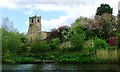
St Mary Magdalene Parish Church
A history of the church copied from the church's website http://www.yarmchurch.co.uk/history.html :
"The present church building is the third to stand on this site. The first church to be built here was Saxon. This would have been built of wood, so no traces of it remain. In a way all the material evidence of its existence is a piece of inscribed stone which was found in Yarm in 1877 by Canon Greenwell of Durham, and was being used as a mangle weight. The stone which measures 660mm high × 330mm wide × 184mm deep is part of a sandstone grave cross and bears the inscription:
+ orate PRO truMBERENCT + SAC +
ALLA + SIGNUM AEFTER HIS BREODERA YSETAE
The small letters indicate gaps in the inscription. The first line is in Latin and translates as 'Pray ye for Trumberhet, Bishop'. The second line is in Latin and the old North English tongue and translates as 'Alla this memorial after his brother set', or more familiarly, 'Alla set up this memorial to his brother'.
The stone is now known as the Trumbert Shaft and is kept in Durham Cathedral library.
It is known that Trumberhet was consecrated as Bishop of Hexham in 681 AD but was driven south by the Picts a few years later. He was succeeded as Bishop of Hexham in 684 AD by Eata. The date of his death is not known but clearly he was buried at Yarm late in the 7th or early in the 8th century. Since he was buried here there was a graveyard, and if there was a graveyard, there was a church.
The Norman Church
The remains of the second church, the first stone one built by the De Brus family in the latter half of the 12th century are rather more substantial as they form part of the west end and the base of the tower of the present building. As the west end measures 39 feet (10 metres) in width the nave of that building would have been about 33 feet (8 metres) wide, about half the width of the present building.
In the course of the six centuries for which this building served Yarm it would of course have been adapted and altered many times. A tower was added in the 13th century but appears for some reason to have been rebuilt in the 15th century. At one time the tower may have been open to the nave as there is an archway, now infilled, springing from corbels in what is now the third storey of the tower, and visible only from within the tower. The top of this arch, which is in the pointed (or Gothic) style, not the rounded Norman one, gives a good indication of the roof height of the building.
The Georgian Church
In 1728 the Norman church was so badly damaged by fire that it had to be rebuilt. The cost of the damage was put at £1,772 (no, this is not a misprint! But it is some indication of how prices have changed in the last 270 years), and this was raised by public subscription. A 'Brief' granted by George II allowed collections to be made at churches throughout the land to help finance the rebuilding. This was so successful that this Georgian church was completed by 1730 re-using much of the stone from the earlier building.
The last major addition to the structure of the building was in 1906 when the choir vestry was built by Mr J W Todd of Liverpool in memory of his parents James and Mary Todd. James Todd had been a Churchwarden at Yarm for a total of 23 years, including a continuous spell of 20 years from 1848 to 1868."
Image: © Mick Garratt
Taken: 2 May 2009
0.06 miles
7
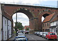
Two of the arches of the Yarm Viaduct from Bridge Street
The building of Yarm viaduct took place over 4 years and the building materials were hauled into position by teams of horses and a pulley system.
Cost: £44,500
Length: 760 yards long
Arches : 43, two of which carry the railway over the River Tees
Height of arches: 65ft high
Amount of stone used: 139,000 cubic feet
Number of bricks used: over seven and a half million
Designers: Thomas Grainger and John Bourne of Edinburgh
Official opening: May 1852
Image: © Pauline E
Taken: 16 Jun 2011
0.06 miles
8
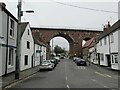
The aptly named Bridge Street
The street goes through one of the 43 arches of this railway viaduct built in 1849
Image: © Martin Dawes
Taken: 31 Jul 2021
0.06 miles
9
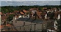
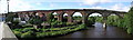
Yarm: rooftops from the railway viaduct
Image: © Christopher Hilton
Taken: 11 Jul 2015
0.06 miles
10
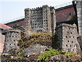
Yarm Castle
Yarm Castle... no really, it does exist, but you need to look hard for it! Go to the back of the High Street, into West Street and look in the area opposite the end of the Churchyard. The 'castle' is somewhat bijou, being only about 3 feet high, but has been there a long time, at least the 28 years I've known it for...
Image: © Alistair Campbell
Taken: 3 Jul 2006
0.06 miles