IMAGES TAKEN NEAR TO
Middleton-on-Leven, YARM, TS15 0JU
Introduction
This page details the photographs taken nearby to TS15 0JU by members of the Geograph project.
The Geograph project started in 2005 with the aim of publishing, organising and preserving representative images for every square kilometre of Great Britain, Ireland and the Isle of Man.

There are currently over 7.5m images from over14,400 individuals and you can help contribute to the project by visiting https://www.geograph.org.uk
Image Map
Images are licensed for reuse under creativecommons.org/licenses/by-sa/2.0
Notes
- Clicking on the map will re-center to the selected point.
- The higher the marker number, the further away the image location is from the centre of the postcode.
Image Listing (11 Images Found)
Images are licensed for reuse under creativecommons.org/licenses/by-sa/2.0
Image
Details
Distance
2
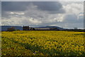
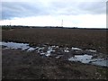
Middleton Grange Farm
Nestled between the oilseed rape and the Cleveland Hills
Image: © Tony Simms
Taken: 29 Apr 2015
0.06 miles
3
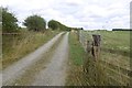
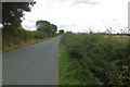
Farm road, Maltby
Unsealed road into Indian Farm.
Image: © Richard Webb
Taken: 10 Aug 2016
0.06 miles
4

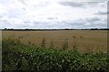
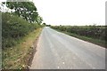
Minor road near Goslingmire Farm
This photograph shows a view of the minor road that runs between Middleton-on-Leven (ahead) and Hutton Rudby (behind the photographer). The picture was taken looking in a north-north-westerly direction towards Foxton Lodge Farm.
Image: © Philip Barker
Taken: 2 Oct 2010
0.07 miles
5
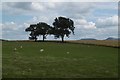
Sheep near Middleton Grange
A contrasting field in a mostly arable area.
Image: © Richard Webb
Taken: 10 Aug 2016
0.08 miles
7
Minor road near Middleton Grange
This photograph shows a view of a section of the minor road that runs between Middleton-on-Leven (behind the photographer) and Hutton Rudby (ahead). This part of the road passes through the north-east corner of the grid-square. Middleton Grange is just visible on the horizon in the right-hand side of the image. The picture was taken looking in a south-south-easterly direction towards Folly Hill.
Image: © Philip Barker
Taken: 2 Oct 2010
0.15 miles
8

Middleton Road heading north
National Cycle Route #65.
Image: © JThomas
Taken: 15 Dec 2012
0.18 miles