IMAGES TAKEN NEAR TO
Stokesley Road, YARM, TS15 0JS
Introduction
This page details the photographs taken nearby to Stokesley Road, TS15 0JS by members of the Geograph project.
The Geograph project started in 2005 with the aim of publishing, organising and preserving representative images for every square kilometre of Great Britain, Ireland and the Isle of Man.

There are currently over 7.5m images from over14,400 individuals and you can help contribute to the project by visiting https://www.geograph.org.uk
Image Map
Images are licensed for reuse under creativecommons.org/licenses/by-sa/2.0
Notes
- Clicking on the map will re-center to the selected point.
- The higher the marker number, the further away the image location is from the centre of the postcode.
Image Listing (7 Images Found)
Images are licensed for reuse under creativecommons.org/licenses/by-sa/2.0
Image
Details
Distance
1
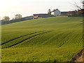
Windy Hill farmhouse
Basking in the autumn sun at 3pm in mid November.
Image: © Christine Johnstone
Taken: 15 Nov 2018
0.02 miles
2
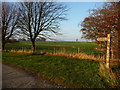
Public bridleway signpost, east of Windy Hill
The bridleway runs west from Holme Lane, to Foxton and beyond.
Image: © Christine Johnstone
Taken: 15 Nov 2018
0.22 miles
3
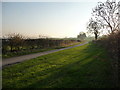
Wide verge on Holme Lane, near Windy Hill
The lane is heading south-west, between Seamer and Hutton Rudby.
Image: © Christine Johnstone
Taken: 15 Nov 2018
0.22 miles
4
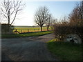
Entrance to Windy Hill Farm, off Holme Lane
The farm access track is also a public bridleway.
Image: © Christine Johnstone
Taken: 15 Nov 2018
0.22 miles
5
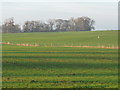
Cust Moor Plantation
Looking north-west from Holme Lane.
Image: © Christine Johnstone
Taken: 15 Nov 2018
0.22 miles
6
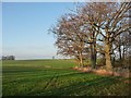
Patch of woodland, east of Windy Hill
Bordered on the east side by Holme Lane.
Image: © Christine Johnstone
Taken: 15 Nov 2018
0.22 miles
7
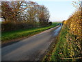
Holme Lane, heading north-east to Seamer
With a 77 metre spot height at the distant minor summit.
Image: © Christine Johnstone
Taken: 15 Nov 2018
0.24 miles