IMAGES TAKEN NEAR TO
Langbaurgh Road, YARM, TS15 0HL
Introduction
This page details the photographs taken nearby to Langbaurgh Road, TS15 0HL by members of the Geograph project.
The Geograph project started in 2005 with the aim of publishing, organising and preserving representative images for every square kilometre of Great Britain, Ireland and the Isle of Man.

There are currently over 7.5m images from over14,400 individuals and you can help contribute to the project by visiting https://www.geograph.org.uk
Image Map (Loading...)


Getting Data...Please wait
Leaflet Map data © OpenStreetMap
Images are licensed for reuse under creativecommons.org/licenses/by-sa/2.0
Notes
- Clicking on the map will re-center to the selected point.
- The higher the marker number, the further away the image location is from the centre of the postcode.
Image Listing (4 Images Found)
Images are licensed for reuse under creativecommons.org/licenses/by-sa/2.0
Image
Details
Distance
1
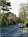
Bellbrough Lane
One of the roads leading out of Hutton Rudby, this one heading towards the A19 and points south.
Image: © Gordon Hatton
Taken: 20 Dec 2020
0.14 miles
2
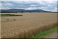
Field, edge of Hutton Rudby
The end of the flatlands loom ahead. View towards the hills across a wheatfield.
Image: © Richard Webb
Taken: 10 Aug 2016
0.16 miles
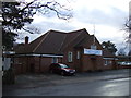
3
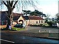
Hutton Rudby Village Hall
Substantially refurbished in 2004.
Image: © Mick Garratt
Taken: 19 Nov 2005
0.21 miles