IMAGES TAKEN NEAR TO
Hutton Rudby, YARM, TS15 0EY
Introduction
This page details the photographs taken nearby to TS15 0EY by members of the Geograph project.
The Geograph project started in 2005 with the aim of publishing, organising and preserving representative images for every square kilometre of Great Britain, Ireland and the Isle of Man.

There are currently over 7.5m images from over14,400 individuals and you can help contribute to the project by visiting https://www.geograph.org.uk
Image Map (Loading...)


Getting Data...Please wait
Leaflet Map data © OpenStreetMap
Images are licensed for reuse under creativecommons.org/licenses/by-sa/2.0
Notes
- Clicking on the map will re-center to the selected point.
- The higher the marker number, the further away the image location is from the centre of the postcode.
Image Listing (28 Images Found)
Images are licensed for reuse under creativecommons.org/licenses/by-sa/2.0
Image
Details
Distance
1
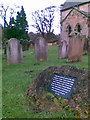
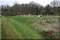
Cholera mound, in All Saints churchyard
The relatively modern tablet records the following :
Under this mound lie the victims of the 1832 epidemic of Asiatic cholera which began on 2 October with the death of John Cook, weaver of Hutton.
It took 23 lives in all among them the doctor, Thomas Pullman. The Rev. Robert Barlow was foremost in aiding his parishioners and is said to have helped dig this grave.
AD MM
http://www.jakesbarn.co.uk/
Image: © Geoff Royle
Taken: 30 Nov 2007
0.02 miles
2
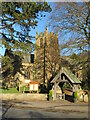
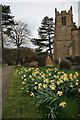
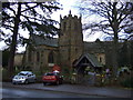
All Saints Church
The church is actually at Rudby in Cleveland, although it serves the combined village of Hutton Rudby.
Image: © Gordon Hatton
Taken: 30 Jan 2023
0.02 miles
3
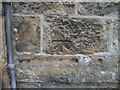
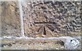
Ordnance Survey Cut Bench Mark
This Ordnance Survey mark was used as part of the levelling process for the OS map of 1853. The height recorded was 165.2ft above the mean sea level at Liverpool.
Image: © Michael Rye
Taken: 7 Jun 2017
0.02 miles
5
Ordnance Survey Cut Mark
This OS cut mark can be found on the west face of All Saints Church. It marks a point 50.283m above mean sea level.
Image: © Adrian Dust
Taken: 30 Nov 2017
0.03 miles
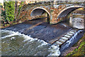
6
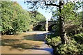
Hutton Bridge and the River Leven
This photograph shows a view of the River Leven as it flows beneath Hutton Bridge in Hutton Rudby. The picture was taken looking in a north-easterly direction towards Skutterskelfe Park.
Image: © Philip Barker
Taken: 30 Sep 2010
0.04 miles
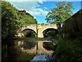
8
Hutton Bridge
The cleft of the River Leven separates the two ancient settlements of Hoton and Rodebi, now widely known together as Hutton Rudby. Hoton, from hoh tun, is Old English meaning high settlement. Rodebi or Rudi's farm is Scandinavian. Two ethnically different communities living side by side and slowly over the years becoming one.
Image: © Mick Garratt
Taken: 12 Dec 2016
0.05 miles
9
Bridge of River Leven, Hutton Rudby
Image: © Paul Buckingham
Taken: 12 Sep 2010
0.06 miles