IMAGES TAKEN NEAR TO
Doctors Lane, YARM, TS15 0EQ
Introduction
This page details the photographs taken nearby to Doctors Lane, TS15 0EQ by members of the Geograph project.
The Geograph project started in 2005 with the aim of publishing, organising and preserving representative images for every square kilometre of Great Britain, Ireland and the Isle of Man.

There are currently over 7.5m images from over14,400 individuals and you can help contribute to the project by visiting https://www.geograph.org.uk
Image Map
Images are licensed for reuse under creativecommons.org/licenses/by-sa/2.0
Notes
- Clicking on the map will re-center to the selected point.
- The higher the marker number, the further away the image location is from the centre of the postcode.
Image Listing (15 Images Found)
Images are licensed for reuse under creativecommons.org/licenses/by-sa/2.0
Image
Details
Distance
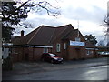
3
Hutton Rudby Village Hall
Substantially refurbished in 2004.
Image: © Mick Garratt
Taken: 19 Nov 2005
0.12 miles
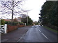
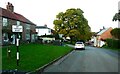
5
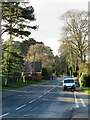
Bellbrough Lane
One of the roads leading out of Hutton Rudby, this one heading towards the A19 and points south.
Image: © Gordon Hatton
Taken: 20 Dec 2020
0.15 miles
6
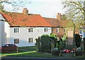
War memorial, Hutton Rudby
On a small island site at the junction of North End and West End.
Image: © Gordon Hatton
Taken: 20 Dec 2020
0.18 miles
7
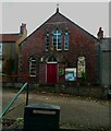
Former Primitive Methodist Chapel, Hutton Rudby
This is now a church hall. I was attracted by the window with small panes of coloured glass, white, grey and yellow arranged randomly.
Image: © Humphrey Bolton
Taken: 26 Oct 2022
0.18 miles
8
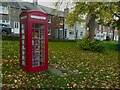
Library in a telephone box, Hutton Rudby
Image: © Humphrey Bolton
Taken: 26 Oct 2022
0.19 miles
9
North End, Hutton Rudby
Here there is an old (pre-Worboys) 'No through road' sign.
Image: © Humphrey Bolton
Taken: 26 Oct 2022
0.19 miles
10
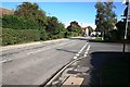
Road junction in Hutton Rudby
This photograph shows a view of a road junction formed by the intersection of Westholme (on the right) with West End (on the left) - from where the photograph was taken. The picture was taken looking in a north-easterly direction towards Hutton Bridge.
Image: © Philip Barker
Taken: 30 Sep 2010
0.19 miles