IMAGES TAKEN NEAR TO
Crathorne, YARM, TS15 0AD
Introduction
This page details the photographs taken nearby to TS15 0AD by members of the Geograph project.
The Geograph project started in 2005 with the aim of publishing, organising and preserving representative images for every square kilometre of Great Britain, Ireland and the Isle of Man.

There are currently over 7.5m images from over14,400 individuals and you can help contribute to the project by visiting https://www.geograph.org.uk
Image Map
Images are licensed for reuse under creativecommons.org/licenses/by-sa/2.0
Notes
- Clicking on the map will re-center to the selected point.
- The higher the marker number, the further away the image location is from the centre of the postcode.
Image Listing (11 Images Found)
Images are licensed for reuse under creativecommons.org/licenses/by-sa/2.0
Image
Details
Distance
1
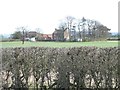
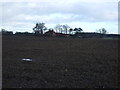
Sand Hills Farm
Seen from the entrance to Moor House Farm. Both farms are in Stockton on Tees [just].
Image: © Christine Johnstone
Taken: 2 Apr 2015
0.01 miles
2
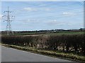
Power lines crossing farmland, south of Long Lane
Industrial Teesside is not far away.
Image: © Christine Johnstone
Taken: 2 Apr 2015
0.09 miles
4
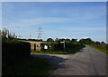
Fingerpost on Long Lane at Clowbeck Boarding Kennels
Image: © Ian S
Taken: 14 Sep 2020
0.15 miles
6
![Long Lane [1]](https://s1.geograph.org.uk/geophotos/04/41/60/4416061_0e1f5adb_120x120.jpg)
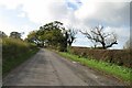
Long Lane [1]
Heading north-east to the A67.
Image: © Christine Johnstone
Taken: 2 Apr 2015
0.17 miles
8
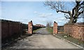
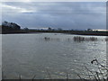
Public footpath to Kirklevington
Also the access road to Moor House Farm [seen in the distance].
Image: © Christine Johnstone
Taken: 2 Apr 2015
0.19 miles
10
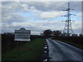
![Long Lane [2]](https://s0.geograph.org.uk/geophotos/04/41/60/4416072_e79f6989_120x120.jpg)
Long Lane [2]
Heading south-west to Picton. There is a 49 metre spot height at the bend.
Image: © Christine Johnstone
Taken: 2 Apr 2015
0.20 miles