IMAGES TAKEN NEAR TO
Crathorne, YARM, TS15 0AB
Introduction
This page details the photographs taken nearby to TS15 0AB by members of the Geograph project.
The Geograph project started in 2005 with the aim of publishing, organising and preserving representative images for every square kilometre of Great Britain, Ireland and the Isle of Man.

There are currently over 7.5m images from over14,400 individuals and you can help contribute to the project by visiting https://www.geograph.org.uk
Image Map
Images are licensed for reuse under creativecommons.org/licenses/by-sa/2.0
Notes
- Clicking on the map will re-center to the selected point.
- The higher the marker number, the further away the image location is from the centre of the postcode.
Image Listing (6 Images Found)
Images are licensed for reuse under creativecommons.org/licenses/by-sa/2.0
Image
Details
Distance
1
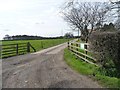
Main entrance to Glebe Farm
Running west from York Street.
Image: © Christine Johnstone
Taken: 2 Apr 2015
0.04 miles
2
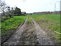
Track heading west towards Glebe Farm
On the west side of York Street. Not the main entrance to the farm.
Image: © Christine Johnstone
Taken: 2 Apr 2015
0.04 miles
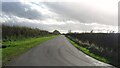
3
![York Street [2]](https://s2.geograph.org.uk/geophotos/04/41/60/4416058_76385cc4_120x120.jpg)
York Street [2]
Heading south from the 58 metre spot height at Glebe Farm.
Image: © Christine Johnstone
Taken: 2 Apr 2015
0.06 miles
4
![York Street [1]](https://s0.geograph.org.uk/geophotos/04/41/60/4416052_47d9ec64_120x120.jpg)
York Street [1]
Heading north from Glebe Farm.
Image: © Christine Johnstone
Taken: 2 Apr 2015
0.06 miles
6
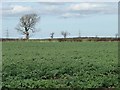
Arable field between Back Lane and York Street
With a fine tree on the field boundary.
Image: © Christine Johnstone
Taken: 2 Apr 2015
0.24 miles