IMAGES TAKEN NEAR TO
Crescent Road, MIDDLESBROUGH, TS1 4QT
Introduction
This page details the photographs taken nearby to Crescent Road, TS1 4QT by members of the Geograph project.
The Geograph project started in 2005 with the aim of publishing, organising and preserving representative images for every square kilometre of Great Britain, Ireland and the Isle of Man.

There are currently over 7.5m images from over14,400 individuals and you can help contribute to the project by visiting https://www.geograph.org.uk
Image Map
Images are licensed for reuse under creativecommons.org/licenses/by-sa/2.0
Notes
- Clicking on the map will re-center to the selected point.
- The higher the marker number, the further away the image location is from the centre of the postcode.
Image Listing (5 Images Found)
Images are licensed for reuse under creativecommons.org/licenses/by-sa/2.0
Image
Details
Distance
1
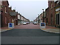
Costa Street, Middlesbrough
Child friendly.
Image: © Mick Garratt
Taken: 20 May 2005
0.12 miles
2
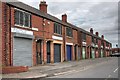
Lorne Street
Once upon a time terraced housing but now converted to small industrial units. And seemingly underused.
Image: © Mick Garratt
Taken: 15 Jul 2008
0.17 miles
3
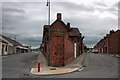
Samuelson Workingman's Club
Or The Samuelson Club as it seems to be known now. In the wedge between Parliament Street on the left and Leven Street on the right.
Image: © Mick Garratt
Taken: 15 Jul 2008
0.19 miles
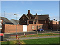
5
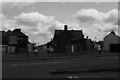
Leven Street and Parliament Road converging on Newport Road, Middlesbrough
Image: © Christopher Hilton
Taken: 12 Jul 2015
0.25 miles