IMAGES TAKEN NEAR TO
Aire Street, MIDDLESBROUGH, TS1 4PQ
Introduction
This page details the photographs taken nearby to Aire Street, TS1 4PQ by members of the Geograph project.
The Geograph project started in 2005 with the aim of publishing, organising and preserving representative images for every square kilometre of Great Britain, Ireland and the Isle of Man.

There are currently over 7.5m images from over14,400 individuals and you can help contribute to the project by visiting https://www.geograph.org.uk
Image Map (Loading...)


Getting Data...Please wait
Leaflet Map data © OpenStreetMap
Images are licensed for reuse under creativecommons.org/licenses/by-sa/2.0
Notes
- Clicking on the map will re-center to the selected point.
- The higher the marker number, the further away the image location is from the centre of the postcode.
Image Listing (12 Images Found)
Images are licensed for reuse under creativecommons.org/licenses/by-sa/2.0
Image
Details
Distance
1
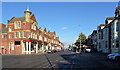
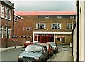
Costa Street, Middlesbrough
Child friendly.
Image: © Mick Garratt
Taken: 20 May 2005
0.12 miles
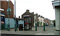
2
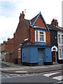
Athol Street
Athol Street looking towards Gresham Road
Image: © Mike Guess
Taken: 26 Sep 2006
0.16 miles
3
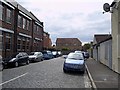
Warwick Street
Street which used to lead to the main gates at Ayresome Park football ground.
Image
Image: © Stephen McCulloch
Taken: 9 May 2007
0.19 miles
4
Ayresome Park main entrance
The main entrance to Middlesbrough FC's old ground taken in 1995.
Modern view Image
The gates now stand outside of the Riverside Stadium Image
Image: © Stephen McCulloch
Taken: 5 Jun 1995
0.20 miles
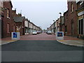
6
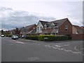
Ayresome Park estate
Housing development on the site of the former football ground.
As it was Image
Image: © Stephen McCulloch
Taken: 9 May 2007
0.23 miles
7
Ayresome Park in 1991
Middlesbrough F.C. moved from Ayresome Park to the Riverside Stadium in 1995.
Image: © Steve Daniels
Taken: 9 Mar 1991
0.24 miles
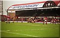
8
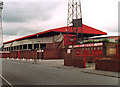
East Stand, Ayresome Park
Middlesbrough FC's former ground, pictured in 1995.
Same view as Image
Image: © Stephen McCulloch
Taken: 5 Jun 1995
0.24 miles
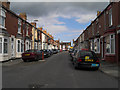
9
Warren Street From Union Street
The council has blocked many of these streets off to prevent rat runs occurring.
Image: © Mick Garratt
Taken: 17 Oct 2006
0.24 miles