IMAGES TAKEN NEAR TO
GUISBOROUGH, TS14 9AJ
Introduction
This page details the photographs taken nearby to TS14 9AJ by members of the Geograph project.
The Geograph project started in 2005 with the aim of publishing, organising and preserving representative images for every square kilometre of Great Britain, Ireland and the Isle of Man.

There are currently over 7.5m images from over14,400 individuals and you can help contribute to the project by visiting https://www.geograph.org.uk
Image Map
Images are licensed for reuse under creativecommons.org/licenses/by-sa/2.0
Notes
- Clicking on the map will re-center to the selected point.
- The higher the marker number, the further away the image location is from the centre of the postcode.
Image Listing (12 Images Found)
Images are licensed for reuse under creativecommons.org/licenses/by-sa/2.0
Image
Details
Distance
1
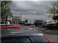
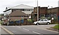
Sainsbury's supermarket
Morrisons have a similar size store in the town and there's a smaller Cooperative store and filling station on the bypass one square north.
Image: © Colin Grice
Taken: 20 Aug 2010
0.12 miles
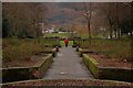
3
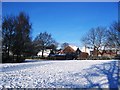
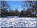
Snow-laden Park, Guisborough (view north)
This photograph shows a view of a snow-laden park area opposite Sainsbury's supermarket in Rectory Lane, Guisborough. The picture was taken looking in a northerly direction towards Chapel Beck. The stone bridge over the beck can just be seen in the centre of the picture.
Image: © Philip Barker
Taken: 4 Jan 2010
0.19 miles
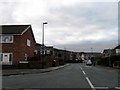
5
Rectory Lane
The building on the right originally I think the reception block for the Hutton Blackett Foundry. It is now known as HCL House after its occupants Hutton Chemicals Ltd. The foundry has long since been demolished and replaced by the two story modern office block on the left. The row of houses left centre are also office units.
Image: © Mick Garratt
Taken: 28 Jun 2007
0.20 miles
6
Snow-laden Park, Guisborough (view west)
This photograph shows a view of a snow-laden park area opposite Sainsbury's supermarket in Rectory Lane, Guisborough. The picture was taken looking in a westerly direction towards Chapel Beck.
Image: © Philip Barker
Taken: 4 Jan 2010
0.20 miles
7
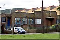
Office Building, Rectory Lane
This office building was originally the reception and administrative office for Blackett Hutton Foundry. The foundry has long since been demolished and the building is now known as HCL House after its occupants Hutton Chemicals Ltd.
Image: © Mick Garratt
Taken: 28 Jun 2007
0.20 miles
8
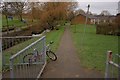
Footpath to Back of Housing
A footpath running alongside Chapel Beck on the left to the back of a small housing estate comprising small bungalows. The child's bike was chained to railings.
Image: © Mick Garratt
Taken: 22 Jan 2008
0.21 miles
9
Westgate Park
Looking south towards the now deforested slope of Highcliff Nab. There is currently a public consultation ongoing about the future of this small park which suffers from periodic bouts of vandalism.
Image: © Mick Garratt
Taken: 22 Jan 2008
0.22 miles
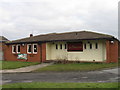
10
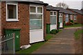
Front of Housing
An estate of small bungalows.
Image: © Mick Garratt
Taken: 22 Jan 2008
0.23 miles