IMAGES TAKEN NEAR TO
Siskin Close, GUISBOROUGH, TS14 8LS
Introduction
This page details the photographs taken nearby to Siskin Close, TS14 8LS by members of the Geograph project.
The Geograph project started in 2005 with the aim of publishing, organising and preserving representative images for every square kilometre of Great Britain, Ireland and the Isle of Man.

There are currently over 7.5m images from over14,400 individuals and you can help contribute to the project by visiting https://www.geograph.org.uk
Image Map
Images are licensed for reuse under creativecommons.org/licenses/by-sa/2.0
Notes
- Clicking on the map will re-center to the selected point.
- The higher the marker number, the further away the image location is from the centre of the postcode.
Image Listing (5 Images Found)
Images are licensed for reuse under creativecommons.org/licenses/by-sa/2.0
Image
Details
Distance
3
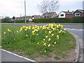
Daffodils in Guisborough
This picture shows a cluster of daffodils on the roadside near the Grove Hill area in Guisborough. The photograph was taken looking west along the minor road that runs from the A173 pass Lowcross Farm
Image: © Philip Barker
Taken: 26 Apr 2008
0.19 miles
4
The 'old' Guisborough road
This photograph shows a view of part of the 'old' Guisborough road near the entrance to Scugdale Farm. This road is now used primarily to provide access to local farms from the A171 dual carriageway which lies about 130 yards to the right. This picture was taken looking in an easterly direction towards the roundabout at Woodhouse.
Image: © Philip Barker
Taken: 20 Feb 2010
0.25 miles
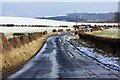
5
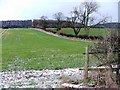
Field, Scugdale Farm
View north from the old Guisborough Road with West Hills in the distance.
Image: © Mick Garratt
Taken: 16 Mar 2006
0.25 miles