IMAGES TAKEN NEAR TO
Middlesbrough Road, GUISBOROUGH, TS14 8JT
Introduction
This page details the photographs taken nearby to Middlesbrough Road, TS14 8JT by members of the Geograph project.
The Geograph project started in 2005 with the aim of publishing, organising and preserving representative images for every square kilometre of Great Britain, Ireland and the Isle of Man.

There are currently over 7.5m images from over14,400 individuals and you can help contribute to the project by visiting https://www.geograph.org.uk
Image Map (Loading...)


Getting Data...Please wait
Leaflet Map data © OpenStreetMap
Images are licensed for reuse under creativecommons.org/licenses/by-sa/2.0
Notes
- Clicking on the map will re-center to the selected point.
- The higher the marker number, the further away the image location is from the centre of the postcode.
Image Listing (5 Images Found)
Images are licensed for reuse under creativecommons.org/licenses/by-sa/2.0
Image
Details
Distance
2
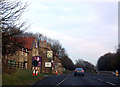
A171 approaching the Premier Inn and Cross Keys
Image: © JThomas
Taken: 12 Nov 2011
0.13 miles
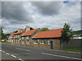
3
The Cross Keys Inn near Hemble Hill
The Inn is part of the Chef and Brewer chain.
Image: © Steve Daniels
Taken: 2 Jun 2012
0.13 miles
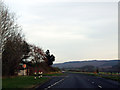
5
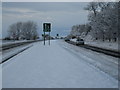
Traffic on the A171 road (view west)
This photograph shows the traffic flow on the east-bound carriageway of the A171 road near Mill Farm. The picture was taken looking in a westerly direction towards Swan's Corner and Nunthorpe.
Image: © Philip Barker
Taken: 20 Dec 2009
0.16 miles