IMAGES TAKEN NEAR TO
Lyndale, GUISBOROUGH, TS14 8JN
Introduction
This page details the photographs taken nearby to Lyndale, TS14 8JN by members of the Geograph project.
The Geograph project started in 2005 with the aim of publishing, organising and preserving representative images for every square kilometre of Great Britain, Ireland and the Isle of Man.

There are currently over 7.5m images from over14,400 individuals and you can help contribute to the project by visiting https://www.geograph.org.uk
Image Map (Loading...)


Getting Data...Please wait
Leaflet Map data © OpenStreetMap
Images are licensed for reuse under creativecommons.org/licenses/by-sa/2.0
Notes
- Clicking on the map will re-center to the selected point.
- The higher the marker number, the further away the image location is from the centre of the postcode.
Image Listing (9 Images Found)
Images are licensed for reuse under creativecommons.org/licenses/by-sa/2.0
Image
Details
Distance
1
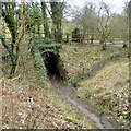
Creep beneath the Middlesbrough & Guisborough Railway originally to a farm called Barn Hill
Image: © Mick Garratt
Taken: 2 Mar 2021
0.10 miles
2
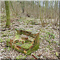
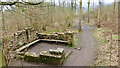
Brick structure on the site of Bousdale brickworks
Image: © Mick Garratt
Taken: 2 Mar 2021
0.12 miles
5

Ducks on Ice
A close one this. Which Grid Square? View north east from the old railway at Pinchinthorp.
Image: © Mick Garratt
Taken: 4 Feb 2006
0.17 miles
6

Guisborough Walkway Woodland Festival 2008
Demonstration of wood carving by a man with a chainsaw.
Image: © Mick Garratt
Taken: 14 Sep 2008
0.19 miles
7
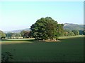
Trees in the shadow of Guisborough Forest
A lovely October afternoon walk
Image: © mark harrington
Taken: 16 Oct 2005
0.20 miles
8
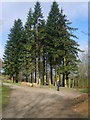
In Bousdale Wood
In the plantations near Hutton
Image: © Michael Graham
Taken: 8 Apr 2010
0.23 miles
9
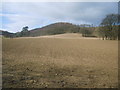
Farmland at Hutton
Walking through the plantations near Hutton Gate.
Image: © Michael Graham
Taken: 8 Apr 2010
0.23 miles