IMAGES TAKEN NEAR TO
Farndale Drive, GUISBOROUGH, TS14 8JA
Introduction
This page details the photographs taken nearby to Farndale Drive, TS14 8JA by members of the Geograph project.
The Geograph project started in 2005 with the aim of publishing, organising and preserving representative images for every square kilometre of Great Britain, Ireland and the Isle of Man.

There are currently over 7.5m images from over14,400 individuals and you can help contribute to the project by visiting https://www.geograph.org.uk
Image Map (Loading...)


Getting Data...Please wait
Leaflet Map data © OpenStreetMap
Images are licensed for reuse under creativecommons.org/licenses/by-sa/2.0
Notes
- Clicking on the map will re-center to the selected point.
- The higher the marker number, the further away the image location is from the centre of the postcode.
Image Listing (3 Images Found)
Images are licensed for reuse under creativecommons.org/licenses/by-sa/2.0
Image
Details
Distance
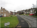
2

Post Box on The Avenue, Guisborough
Corner of Farndale Drive
Image: © doug scarr
Taken: 15 Jan 2013
0.12 miles
3
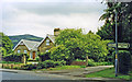
Hutton Lane, near site of Hutton Gate station
View SE to the edge of the Cleveland Hills (Cod Hill, 1,024 ft.). The station had been in the trees on the right and was on the ex-NER line from Middlesbrough to Guisborough, Brotton, Loftus, Whitby and Scarborough. The station had been closed 2/3/53, but a passenger service (Middlesbrough - Guisborough - Loftus only) continued until 2/5/60 and the line remained open for freight until 2/3/64.
Image: © Ben Brooksbank
Taken: 24 Jun 1997
0.25 miles