IMAGES TAKEN NEAR TO
Pinchinthorpe, GUISBOROUGH, TS14 8HE
Introduction
This page details the photographs taken nearby to Pinchinthorpe, TS14 8HE by members of the Geograph project.
The Geograph project started in 2005 with the aim of publishing, organising and preserving representative images for every square kilometre of Great Britain, Ireland and the Isle of Man.

There are currently over 7.5m images from over14,400 individuals and you can help contribute to the project by visiting https://www.geograph.org.uk
Image Map
Images are licensed for reuse under creativecommons.org/licenses/by-sa/2.0
Notes
- Clicking on the map will re-center to the selected point.
- The higher the marker number, the further away the image location is from the centre of the postcode.
Image Listing (5 Images Found)
Images are licensed for reuse under creativecommons.org/licenses/by-sa/2.0
Image
Details
Distance
1
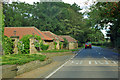
A173 passes Pinchinthorpe House
The low buildings are, or were, the stables.
Image: © Robin Webster
Taken: 7 Oct 2011
0.03 miles
2
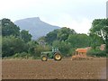
Farm Working, Pinchinthorp
With Roseberry Topping (NZ5712) in the distance.
Image: © Mick Garratt
Taken: 25 Sep 2005
0.14 miles
3
Pinchingthorpe 2nd railway station (site), Yorkshire
Opened in 1876 by the North Eastern Railway on the line from Middlesbrough to Guisborough, this station closed to passengers in 1951. It had replaced an earlier station some 150 metres behind the camera position.
View west towards Nunthorpe & Middlesbrough. The spelling of the station name was slightly different to the nearby settlement until 1920 when it was corrected.
Image: © Nigel Thompson
Taken: 10 Oct 2009
0.24 miles
4
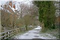
Old Middlesbrough to Whitby Railway
Now made into a walkway and cycleway although for bikers it's a no through road.
Image: © Mick Garratt
Taken: 20 Mar 2007
0.25 miles
5
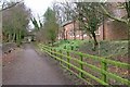
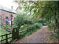
Former Pinchinthorpe Station
Closed in 1951 and now a private residence. The branch line itself continued to operate to Guisborough until it was closed in 1964 under the Beeching Axe. This section is now a public cycleway and nature reserve.
Image: © Mick Garratt
Taken: 4 Mar 2008
0.25 miles