IMAGES TAKEN NEAR TO
Hutton Village, GUISBOROUGH, TS14 8EP
Introduction
This page details the photographs taken nearby to Hutton Village, TS14 8EP by members of the Geograph project.
The Geograph project started in 2005 with the aim of publishing, organising and preserving representative images for every square kilometre of Great Britain, Ireland and the Isle of Man.

There are currently over 7.5m images from over14,400 individuals and you can help contribute to the project by visiting https://www.geograph.org.uk
Image Map (Loading...)


Getting Data...Please wait
Leaflet Map data © OpenStreetMap
Images are licensed for reuse under creativecommons.org/licenses/by-sa/2.0
Notes
- Clicking on the map will re-center to the selected point.
- The higher the marker number, the further away the image location is from the centre of the postcode.
Image Listing (7 Images Found)
Images are licensed for reuse under creativecommons.org/licenses/by-sa/2.0
Image
Details
Distance
1
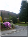
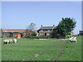
Hutton Village
Delightful village tucked under the plantations above Guisborough
Image: © Michael Graham
Taken: 8 Apr 2010
0.05 miles
3
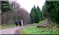
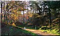
The Unsuitables
A 'green' lane linking Hutton Lowcross with the Westerdale road. 'The Unsuitables' is a local name given because of the sign at the bottom of the climb which says that the track is unsuitable for vehicles although it is perfectly legal to do so. A few years ago it was graded because, according to the man in the JCB doing the job, the council was scared of the comeback if someone did try to take their cars along it.
Image: © Mick Garratt
Taken: 18 Nov 2006
0.17 miles
4
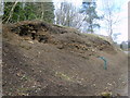
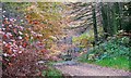
In Hutton Wood
The shale bank is a site where many fossils have been found. I ressited the temptation to dig for more.
Image: © Michael Graham
Taken: 8 Apr 2010
0.20 miles
5

Hill Plain above Guisborough as seen from Highcliff Nab
Image: © Colin Park
Taken: 23 Apr 1998
0.22 miles
7
Forest Track and Gate, Hutton Lowcross
Image: © Mick Garratt
Taken: 18 Nov 2006
0.25 miles