IMAGES TAKEN NEAR TO
Stokesley Road, GUISBOROUGH, TS14 8DL
Introduction
This page details the photographs taken nearby to Stokesley Road, TS14 8DL by members of the Geograph project.
The Geograph project started in 2005 with the aim of publishing, organising and preserving representative images for every square kilometre of Great Britain, Ireland and the Isle of Man.

There are currently over 7.5m images from over14,400 individuals and you can help contribute to the project by visiting https://www.geograph.org.uk
Image Map (Loading...)


Getting Data...Please wait
Leaflet Map data © OpenStreetMap
Images are licensed for reuse under creativecommons.org/licenses/by-sa/2.0
Notes
- Clicking on the map will re-center to the selected point.
- The higher the marker number, the further away the image location is from the centre of the postcode.
Image Listing (7 Images Found)
Images are licensed for reuse under creativecommons.org/licenses/by-sa/2.0
Image
Details
Distance
1

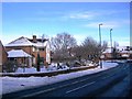
Stokesley Road, Guisborough
Autumnal view of the Stokesley Road in Guisborough.
Image: © doug scarr
Taken: 19 Nov 2013
0.03 miles
2
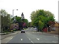
Houses in Stokesley Road, Guisborough
This photograph shows some of the houses located on Stokesley Road, Guisborough. The picture was taken looking in a north-north-easterly direction towards the road junction and Chapel Beck.
Image: © Philip Barker
Taken: 4 Jan 2010
0.08 miles
4
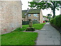
Ruther Cross
Marking the one mile point on the old Guisborough to Kildale pannier route. Now enclosed by a modern housing estate.
Image: © Mick Garratt
Taken: 24 May 2005
0.21 miles

7
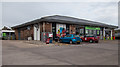
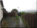
Co-operative Service station and convenience store
There is a surprisingly extensive 'mini' supermarket inside.
Image: © Colin Grice
Taken: 22 Oct 2014
0.24 miles