IMAGES TAKEN NEAR TO
Beaufort Close, GUISBOROUGH, TS14 7PW
Introduction
This page details the photographs taken nearby to Beaufort Close, TS14 7PW by members of the Geograph project.
The Geograph project started in 2005 with the aim of publishing, organising and preserving representative images for every square kilometre of Great Britain, Ireland and the Isle of Man.

There are currently over 7.5m images from over14,400 individuals and you can help contribute to the project by visiting https://www.geograph.org.uk
Image Map (Loading...)


Getting Data...Please wait
Leaflet Map data © OpenStreetMap
Images are licensed for reuse under creativecommons.org/licenses/by-sa/2.0
Notes
- Clicking on the map will re-center to the selected point.
- The higher the marker number, the further away the image location is from the centre of the postcode.
Image Listing (7 Images Found)
Images are licensed for reuse under creativecommons.org/licenses/by-sa/2.0
Image
Details
Distance
1

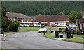
Outside the Huntsman
Refreshment taken the walk continues on an urban leg.
Image: © Michael Graham
Taken: 8 Apr 2010
0.15 miles
3

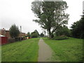
On the Branch Line
The disused rail line now a footpath through housing estates
Image: © Michael Graham
Taken: 8 Apr 2010
0.15 miles
5
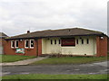
Enfield Chase Shops
The last unit on the right is the Indian Cottage, a renowned Indian restaurant.
Image: © Mick Garratt
Taken: 28 Jun 2007
0.18 miles
6
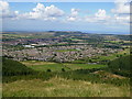
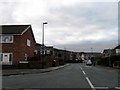
Guisborough housing estates seen from the Cleveland Way
You also get a good view of the North Sea from here. The picture was taken from Highcliff Nab in square NZ6113.
Image: © Phil Catterall
Taken: 23 Aug 2006
0.19 miles