IMAGES TAKEN NEAR TO
Enfield Chase, GUISBOROUGH, TS14 7LT
Introduction
This page details the photographs taken nearby to Enfield Chase, TS14 7LT by members of the Geograph project.
The Geograph project started in 2005 with the aim of publishing, organising and preserving representative images for every square kilometre of Great Britain, Ireland and the Isle of Man.

There are currently over 7.5m images from over14,400 individuals and you can help contribute to the project by visiting https://www.geograph.org.uk
Image Map
Images are licensed for reuse under creativecommons.org/licenses/by-sa/2.0
Notes
- Clicking on the map will re-center to the selected point.
- The higher the marker number, the further away the image location is from the centre of the postcode.
Image Listing (10 Images Found)
Images are licensed for reuse under creativecommons.org/licenses/by-sa/2.0
Image
Details
Distance
1
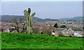
Pasture, Off Belmangate
Overlooking Hunters Hill housing estate.
Image: © Mick Garratt
Taken: 3 Dec 2006
0.10 miles
2
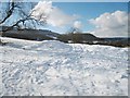
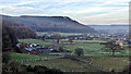
Snow-laden field near Belman Bank
This photograph shows a view of a snow-laden field near Belman Bank in Guisborough. High Cliff Nab can just be seen on the horizon; it is also possible to see some of the trees in Kemplah Wood. Just beyond the snow, it is possible to see the roof-tops of some of the houses in the Hunter Hill housing estate. This picture was taken from the public footpath that runs from Belman Bank towards Guisborough. The viewing direction was south-west (approximately).
Image: © Philip Barker
Taken: 22 Feb 2010
0.11 miles
3
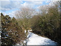
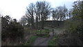
Footpath from Belman Bank
This photograph shows a view of a part of the snow-laden public footpath that runs between Belman Bank and the minor road near Brown Hill in Guisborough. The picture was taken looking in a north-north-westerly direction towards Guisborough.
Image: © Philip Barker
Taken: 22 Feb 2010
0.13 miles
4
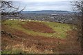
A View Across Guisborough to the Eston Hills
Image: © Mick Garratt
Taken: 27 Dec 2008
0.19 miles
5
Tree-house at Hunter Hill Farm
This photograph shows a view of a tree-house at Hunter Hill Farm. The picture was taken from the public footpath that passes by the west side of the farm. The viewing direction was north-east towards Brown Hill.
Image: © Philip Barker
Taken: 22 Feb 2010
0.20 miles
7

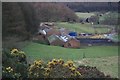
Hunter Hill Farm
With housing on the edge of Guisborough in shot.
Image: © Michael Graham
Taken: 8 Apr 2010
0.21 miles
8
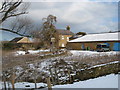
Belmont Ironstone Mine
Early morning. A good day beckons but Guisborough has not yet escaped the shadow of Highcliff Nab. Morning mist creeps up from the Cleveland valley. The range of buildings on the left was stables built for the Bolckow, Vaughan and Company’s Belmont Ironstone Mine when they drove a new drift to old workings which operated between 1907 and 1921. Today they are still used as stables but I remember a time in the late 1970s when pigs were kept there. On the right is the old Hunter Hill Farm which has now been converted into multiple residences.
From my blog http://www.fhithich.uk/?p=20612
Image: © Mick Garratt
Taken: 27 Dec 2018
0.22 miles
9

Former workshops and stables, Belmont Ironstone mine
Around the back of the impressive range of buildings used for stabling the ponies that were used underground in the Belmont Ironstone Mine. They are probably the best-preserved surface remains of mine buildings in Cleveland and have found use once again for stables. In the 1970s I remember them being used for housing pigs. Or at least pigs use to roam around the back here.
From my photo-diary for 22nd February 2020 see http://www.fhithich.uk/?p=22351
Image: © Mick Garratt
Taken: 22 Feb 2020
0.22 miles
10
Former Mine Buildings
These were associated with the Belmont Ironstone Mine. They were mostly used for stabling the horses used underground. In the seventies they housed pigs. Now they are being re-used as stables.
Image: © Mick Garratt
Taken: 27 Dec 2007
0.23 miles