IMAGES TAKEN NEAR TO
Middlesbrough Road, GUISBOROUGH, TS14 6RR
Introduction
This page details the photographs taken nearby to Middlesbrough Road, TS14 6RR by members of the Geograph project.
The Geograph project started in 2005 with the aim of publishing, organising and preserving representative images for every square kilometre of Great Britain, Ireland and the Isle of Man.

There are currently over 7.5m images from over14,400 individuals and you can help contribute to the project by visiting https://www.geograph.org.uk
Image Map
Images are licensed for reuse under creativecommons.org/licenses/by-sa/2.0
Notes
- Clicking on the map will re-center to the selected point.
- The higher the marker number, the further away the image location is from the centre of the postcode.
Image Listing (3 Images Found)
Images are licensed for reuse under creativecommons.org/licenses/by-sa/2.0
Image
Details
Distance
1
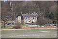
Greenwood Cottages
This photograph shows a view of Greenwood Cottages near Osborne Rush. The picture was taken from the public footpath at Barnaby Side Farm looking in a north-easterly direction towards High Barnaby Farm.
Image: © Philip Barker
Taken: 20 Feb 2010
0.02 miles
2
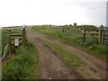
Track from Barnaby Side Farm
This photograph shows a view of the public footpath and the farm access track that passes through Barnaby Side Farm. The picture was taken looking in a northerly direction towards Eston Moor.
Image: © Philip Barker
Taken: 20 Feb 2010
0.12 miles