IMAGES TAKEN NEAR TO
Church Lane, GUISBOROUGH, TS14 6RF
Introduction
This page details the photographs taken nearby to Church Lane, TS14 6RF by members of the Geograph project.
The Geograph project started in 2005 with the aim of publishing, organising and preserving representative images for every square kilometre of Great Britain, Ireland and the Isle of Man.

There are currently over 7.5m images from over14,400 individuals and you can help contribute to the project by visiting https://www.geograph.org.uk
Image Map (14 Images)


Getting Data...Please wait
Leaflet Map data © OpenStreetMap
Images are licensed for reuse under creativecommons.org/licenses/by-sa/2.0
Notes
- Clicking on the map will re-center to the selected point.
- The higher the marker number, the further away the image location is from the centre of the postcode.
Image Listing (14 Images Found)
Images are licensed for reuse under creativecommons.org/licenses/by-sa/2.0
Image
Details
Distance
2
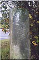
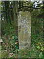
Old Guide Stone by the A173, Church Lane, Guisborough Parish
By the A173, in parish of Guisborough (Redcar and Cleveland District), Ex. Yorkshire North Riding, junction with B1269, Tocketts, at corner of old road opposite cemetery.
Inscription reads:-
North side: Road to Kirk-Leatham; South side: Road to (Whitby); East side: Tockit East; West side: (eroded)
Grade II Listed. List Entry Number: 1159726
https://historicengland.org.uk/listing/the-list/list-entry/1159726
Surveyed
Milestone Society National ID: YN_XGUIS
Image: © Milestone Society
Taken: Unknown
0.04 miles
3
Old guidestone
This guidestone stands at the southwest end of the old road at Tocketts where the newer A173 runs parallel from the traffic island junction with the B1269. It is inscribed on 3 sides. There is a bench mark on the top lefthand side. There are traces of white paint suggesting that it was once painted. It may date from the late 18C or early 19C when guidestones had to be set up on the orders of the local Justices of Peace. Grade II listed 1159726.
Image: © Chris Minto
Taken: 17 Oct 2023
0.04 miles
4
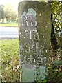
Old guidestone
This is the right-hand face of the guidestone at Tocketts. The legend is Road/To/Kirkl(e)/atham. That is to the north along the B1269 past the cemetery. Grade II listed 1159726.
Image: © Chris Minto
Taken: 17 Oct 2023
0.04 miles
5
Old guidestone
This is front face of the guidestone at Tocketts inscribed Tocket(ts). The left face is inscribed Road/To/Whitby which would have led along the old abandoned section of road. Grade II listed 1159726.
Image: © Chris Minto
Taken: 17 Oct 2023
0.04 miles
6

New Cemetery
The old cemetery, on the far side of the hedge, is in the adjacent square.
Image: © Mick Garratt
Taken: 4 Oct 2007
0.07 miles
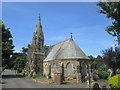
7
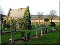
Small Chapel, Guisborough Cemetery
View north west.
Image: © Mick Garratt
Taken: 17 Dec 2005
0.07 miles
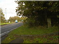
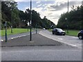
9
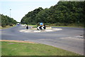
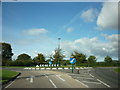
Roundabout near Tocketts Lythe
This photograph shows a view of the roundabout at the junction of the B1269 road with the A173 road near the cemetery at the north-east end of Guisborough. The picture was taken looking in a north-easterly direction towards Tocketts Mill.
Image: © Philip Barker
Taken: 3 Sep 2010
0.12 miles
10
Junction of Church Lane and the A171 at Guisborough
Image: © Eirian Evans
Taken: 15 Sep 2021
0.14 miles