IMAGES TAKEN NEAR TO
Woodhouse Road, GUISBOROUGH, TS14 6LJ
Introduction
This page details the photographs taken nearby to Woodhouse Road, TS14 6LJ by members of the Geograph project.
The Geograph project started in 2005 with the aim of publishing, organising and preserving representative images for every square kilometre of Great Britain, Ireland and the Isle of Man.

There are currently over 7.5m images from over14,400 individuals and you can help contribute to the project by visiting https://www.geograph.org.uk
Image Map
Images are licensed for reuse under creativecommons.org/licenses/by-sa/2.0
Notes
- Clicking on the map will re-center to the selected point.
- The higher the marker number, the further away the image location is from the centre of the postcode.
Image Listing (9 Images Found)
Images are licensed for reuse under creativecommons.org/licenses/by-sa/2.0
Image
Details
Distance
4

The Stand, Guisborough Town Football Club
A Northern League Division Two club.
Image: © Mick Garratt
Taken: 21 Jul 2009
0.18 miles
6
Guisborough Swimming Pool
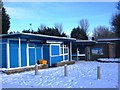
This photograph shows a snow-laden entrance to Guisborough swimming pool after a recent fall of snow in early January. The swimming pool is located within the area occupied by the King George V Playing Fields (see here: Image ). The picture was taken in a north-north-westerly direction looking towards Howlbeck Mill Farm.
Image: © Philip Barker
Taken: 4 Jan 2010
0.21 miles
9
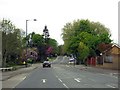
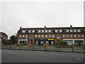
Houses in Stokesley Road, Guisborough
This photograph shows some of the houses located on Stokesley Road, Guisborough. The picture was taken looking in a north-north-easterly direction towards the road junction and Chapel Beck.
Image: © Philip Barker
Taken: 4 Jan 2010
0.25 miles