IMAGES TAKEN NEAR TO
Lumley Terrace, GUISBOROUGH, TS14 6HN
Introduction
This page details the photographs taken nearby to Lumley Terrace, TS14 6HN by members of the Geograph project.
The Geograph project started in 2005 with the aim of publishing, organising and preserving representative images for every square kilometre of Great Britain, Ireland and the Isle of Man.

There are currently over 7.5m images from over14,400 individuals and you can help contribute to the project by visiting https://www.geograph.org.uk
Image Map
Images are licensed for reuse under creativecommons.org/licenses/by-sa/2.0
Notes
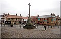
- Clicking on the map will re-center to the selected point.
- The higher the marker number, the further away the image location is from the centre of the postcode.
Image Listing (121 Images Found)
Images are licensed for reuse under creativecommons.org/licenses/by-sa/2.0
Image
Details
Distance
3
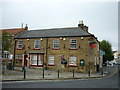
Highland Laddie
Highland Laddie public house Guisborough, North Yorkshire.
Image: © Keith Evans
Taken: 31 May 2010
0.04 miles
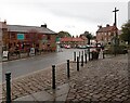
4
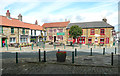
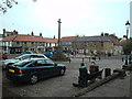
Two sides of a square, Church Street, Guisborough
The other two sides are formed by the church and the wall of the Priory grounds. The house and shops on the left are late 18CC, listed Grade II.
Image: © Humphrey Bolton
Taken: 2 Aug 2020
0.04 miles
5

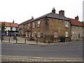
Post box, Church Street, Guisborough
This post box can be seen in context in Image
Image: © habiloid
Taken: 29 Oct 2022
0.05 miles
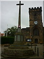
9
Church Street, Guisborough
The war memorial is on the right.
Image: © habiloid
Taken: 29 Oct 2022
0.05 miles