IMAGES TAKEN NEAR TO
Westgate, GUISBOROUGH, TS14 6AW
Introduction
This page details the photographs taken nearby to Westgate, TS14 6AW by members of the Geograph project.
The Geograph project started in 2005 with the aim of publishing, organising and preserving representative images for every square kilometre of Great Britain, Ireland and the Isle of Man.

There are currently over 7.5m images from over14,400 individuals and you can help contribute to the project by visiting https://www.geograph.org.uk
Image Map (Loading...)


Getting Data...Please wait
Leaflet Map data © OpenStreetMap
Images are licensed for reuse under creativecommons.org/licenses/by-sa/2.0
Notes
- Clicking on the map will re-center to the selected point.
- The higher the marker number, the further away the image location is from the centre of the postcode.
Image Listing (57 Images Found)
Images are licensed for reuse under creativecommons.org/licenses/by-sa/2.0
Image
Details
Distance
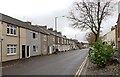
1
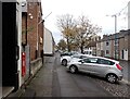
Westgate, Guisborough
A close-up of the post box can be seen in Image
Image: © habiloid
Taken: 29 Oct 2022
0.01 miles
4

Post box, Westgate, Guisborough
This post box can be seen in context in Image
Image: © habiloid
Taken: 29 Oct 2022
0.02 miles
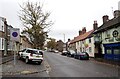
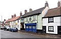
8
Westgate, Guisborough
The main street.
Image: © Robin Webster
Taken: 7 Oct 2011
0.03 miles
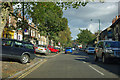
9
Westgate, Guisborough
The main street of the town with the centre ahead.
Image: © Robin Webster
Taken: 7 Oct 2011
0.04 miles
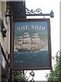
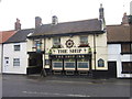
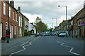
10
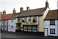
The Ship
The name is evidence of Guisborough being on the route for sailors walking from the Tees to Whitby.
Image: © Mick Garratt
Taken: 21 Dec 2007
0.05 miles